

How to Reach Chandratal Lake from Manali and Kaza: Route, Road Conditions & Camping Guide

Priya Mehta
August 23, 2026
Complete road trip guide on how to reach Chandratal Lake from Manali and Kaza. Detailed route breakdown via Atal Tunnel, Batal, and Kunzum Pass, along with 4x4 tips, parking, and camping rules.
Introduction: The Moon Lake of Spiti
Chandratal Lake, cradled at an elevation of 4,300 metres (14,100 feet) in the Lahaul and Spiti district of Himachal Pradesh, is among the most dramatic high-altitude water bodies in the Indian Himalayas. Named for its distinct crescent moon shape, the turquoise lake rests between scree slopes and rugged snow-capped peaks of the Chandra-Bhaga range. Reaching this remote sanctuary requires navigating high mountain passes, turbulent glacial water crossings (pagal nalas), and rough gravel jeep tracks. Whether you are driving across the newly opened bypasses after crossing the Atal Tunnel from Manali or traversing the high mountain switchbacks from Kaza across Kunzum Pass, understanding the logistics, road conditions, and ecological regulations is essential for a safe journey.
Planning your journey to Chandratal often forms the pinnacle highlight of an 8-day Spiti Valley road trip itinerary. Because the lake sits above 4,300 metres, acute mountain sickness is a real concern, making route selection and gradual altitude acclimatization critical factors in your overall expedition itinerary.
Route 1: Manali to Chandratal via Atal Tunnel and Batal (125 km)
The Manali to Chandratal route is the primary western gateway, spanning approximately 125 kilometres. Following the completion of the Atal Tunnel at Rohtang, travel time has reduced dramatically from the old Rohtang Pass crawl, but the Gramphu-to-Batal stretch remains one of the rawest driving challenges in northern India.
Step-by-Step Route Breakdown:
- Manali to South Portal (Solang Valley - 25 km): Smooth paved double-lane highway through Dhundi.
- Atal Tunnel Transit (9.02 km): Crossing beneath the Pir Panjal range to emerge at the North Portal in Sissu/Teling (Lahaul).
- North Portal to Gramphu Junction (5 km): Turning east onto National Highway 505 (NH505) towards Spiti.
- Gramphu to Chhatru (17 km): Unpaved rocky riverbed terrain alongside the Chandra River. Expect loose gravel, mud, and water runoffs. Chhatru serves as a rustic pitstop with basic dhaba food.
- Chhatru to Batal (32 km): The most demanding off-road segment. You will encounter boulder-strewn trails, sheer drops, and notorious glacial stream crossings including Chhota Dara. High-ground-clearance vehicles (SUVs or 4x4s) are mandatory.
- Batal to Chandratal Diversion & Campsite (14 km): Just before the Batal bridge across the Chandra River, a narrow, unpaved single-track road branches north towards Chandratal. This 14-kilometre cliffside shelf road leads directly to the designated camping area.
Total driving time from Manali under clear weather conditions is approximately 5 to 7 hours depending on water levels at stream crossings.
Route 2: Kaza to Chandratal via Losar and Kunzum Pass (90 km)
If you are travelling clockwise through Spiti or completing a full 9-day Spiti circuit, you will approach Chandratal from Kaza. This 90-kilometre drive climbs over the mighty Kunzum La (4,590 m) before descending toward the Chandratal junction.
Step-by-Step Route Breakdown:
- Kaza to Losar (56 km): Paved and semi-paved road passing through Kiato and Morang along the Spiti River basin. Losar is the last inhabited village on the Spiti side before the pass and has a police check-post where all vehicle details must be registered.
- Losar to Kunzum Pass (19 km): A steep, winding ascent via hairpin bends climbing to Kunzum Top at 4,590 metres. The pass features a revered Buddhist stupa and shrine dedicated to Goddess Kunzum (Kanta Devi), where motorists traditionally make a clockwise circumambulation for safe travels.
- Kunzum Pass to Chandratal Diversion: Descending the western flank of Kunzum La toward Batal, you reach the Chandratal junction road approximately 2 km before Batal bridge.
- Alternative Kunzum-to-Chandratal Trek (8 km): Trekkers often choose to alight at Kunzum Pass and hike the panoramic 8 km ridge-line trail directly down to Chandratal, while their vehicle carries luggage down by road.
Total driving time from Kaza is typically 3.5 to 5 hours. Approaching from Kaza is physiologically safer because travelers are already acclimatized from staying at homestays in Kaza or surrounding high-altitude villages like Kibber and Langza.

The Final 14 km Track, Parking, and Lake Hike
The 14-kilometre spur road from the Batal junction to the Chandratal parking zone is a single-lane mountain shelf cut into steep scree slopes. Vehicles cannot pass each other easily, so drivers must use designated turnouts. In peak monsoon (late July to mid-August), active mudslides and water cascades can temporarily halt traffic.
At the end of this track, all motorized vehicles must park at the designated Forest Department parking ground. Vehicles are strictly prohibited from driving beyond this point. From the parking lot, visitors must complete a gentle 1.5 to 2 kilometre uphill walk (approximately 30 to 45 minutes at this altitude) along a marked gravel trail to reach the shoreline of Chandratal Lake.
Strict Camping Regulations and Accommodation
To protect the fragile alpine wetland ecosystem and prevent contamination of the lake's freshwater basin, the National Green Tribunal (NGT) and Himachal Pradesh Forest Department enforce strict environmental protection laws:
- No Camping Near the Lake Shore: Pitching tents within 3 kilometres of the lake perimeter is strictly banned. Violators face heavy fines.
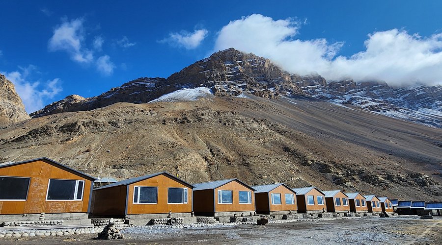
- Designated Commercial Camps: All seasonal commercial tent operators and camps are located in a designated campsite valley approximately 3 to 4 kilometres before the parking lot. You can choose from various eco-camps at Chandratal Lake offering dome tents, Swiss tents with attached bio-toilets, and hot meals.
- Batal Dhabas as an Alternative: For budget backpackers, the historic dhabas at Batal (famously run by Chacha and Chachi) provide shared dormitory beds and hot dal-chawal in stone shelters.

Best Time to Visit Chandratal Lake
Chandratal Lake is accessible only during the summer and early autumn months when Kunzum Pass and the Gramphu-Batal stretch are cleared of heavy winter snow:
- Mid-June to June End: Road opening season. Snow walls border the track near Kunzum Pass; cold temperatures and freezing night conditions.
- July to August: Peak accessibility and lush alpine wildflowers. However, afternoon water levels in glacial nalas (especially Chhota Dara) swell significantly due to rapid snowmelt. 4x4 vehicles are highly recommended.
- September to Early October: The absolute best time for clear skies, mirror-like lake reflections, and stable weather. Night temperatures drop below freezing (-5°C to -10°C), but roads are dry and water streams are manageable.
- Late October to May: Closed. Heavy snowfall shuts Kunzum Pass and the Gramphu road, isolating the basin entirely until the following summer.
Essential Travel & Vehicle Tips for the Chandratal Drive
- Vehicle Selection: A vehicle with minimum 200mm ground clearance is mandatory. While experienced local drivers navigate standard hatchbacks with care, a 4x4 or AWD SUV (like Thar, Scorpio, or Fortuner) significantly reduces the risk of underbody damage.
- Cross Glacial Nalas Early: Glacial melt accelerates under the midday sun. Start your drive from Manali or Kaza by 5:00 AM or 6:00 AM to cross Chhota Dara and Pagal Nala before water volume peaks around 1:00 PM.
- Fuel Availability: The last petrol pump on the Manali side is at Tandi (in Lahaul, 25 km past Atal Tunnel North Portal). The only petrol pump on the Spiti side is in Kaza. Ensure a full tank before leaving either town.
- Connectivity & Offline Maps: Mobile networks (including Jio and Airtel) have zero reception between Gramphu and Losar. Download offline navigation maps and carry a basic first-aid kit with Diamox and oral rehydration salts.
Conclusion
The journey to Chandratal Lake is a classic trans-Himalayan adventure that tests both vehicle capability and mountain driving skills. Whether arriving via the rugged riverbed crossings of Gramphu and Batal or descending from the prayer-flag-strewn heights of Kunzum Pass, the breathtaking sight of the turquoise Moon Lake nestled against barren scree peaks makes every bumpy kilometre thoroughly worthwhile. Plan your acclimatization carefully, respect the fragile high-altitude ecology, and prepare for an unforgettable Himalayan wilderness experience.
Location
Frequently Asked Questions
Q1.Can I drive my own hatchback or sedan to Chandratal Lake?
Q2.How far can vehicles go towards Chandratal Lake?
Q3.Is night camping allowed right next to Chandratal Lake?
Q4.Which route to Chandratal is better: from Manali or from Kaza?
Q5.When does the road to Chandratal open and close each year?
Q6.Are there petrol pumps or phone network reception near Chandratal?
Recommended For You

Spiti Valley Trip: The Complete 9-Day Itinerary
A complete day-by-day 9-day Spiti Valley itinerary from Shimla via Kinnaur to Kaza, Key Monastery, Kibber, and Chandratal Lake, exiting through Manali, with altitude safety and budget notes.

Best Homestays in Kaza Spiti: Traditional Mud-Brick Stays & Valley Views
Discover the best homestays in Kaza, Spiti Valley. Complete guide to mud-brick stays, authentic Spitian food, solar heating, high village circuits, and room tariffs.
Best Hotels in Spiti Valley: Areas, Budget and Tips
Choose the best hotels in Spiti Valley with area-first planning, season timing, and practical booking tips for reliable stays.
Never Miss an Adventure
Get the latest trekking guides, travel tips, and exclusive offers delivered straight to your inbox.
