Shillong Peak: Highest Point Meghalaya
Rahul Garg
January 3, 2026
Visit Shillong Peak, Meghalaya's highest point. Enjoy panoramic views, weather, timings, entry fee & travel tips.
Introduction: The Roof of Meghalaya
At 1,966 meters (6,450 feet) above sea level, Shillong Peak stands as the highest point in Meghalaya, offering visitors some of the most spectacular panoramic views in all of Northeast India. Located just 10 kilometers south of Shillong city, this peak is not merely a geographical high point but a sacred space, home to an Indian Air Force radar station, and one of the most popular viewpoints in the entire region. Known as the "Abode of Clouds," Meghalaya lives up to its name here—on most days, Shillong Peak is surrounded by swirling mists and cloud formations that make the experience almost otherworldly.
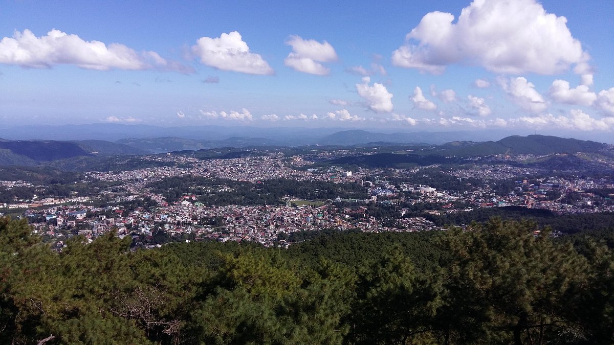
What makes Shillong Peak special is the 360-degree panorama it offers. On a clear day, you can see all of Shillong city spread out below, the sparkling Umiam Lake in the distance, the rolling green hills of the Khasi Hills stretching endlessly, and even the plains of neighboring Bangladesh. It's a view that encompasses urban settlements, pristine water bodies, lush forests, and distant snow-capped Himalayan peaks on exceptionally clear days—all from one vantage point.
Beyond the views, Shillong Peak represents the unique intersection of modern India's strategic infrastructure (the Air Force station) and Meghalaya's natural beauty. While parts of the peak are restricted due to the radar installation, there are designated viewpoints accessible to civilians, making this a must-visit attraction for anyone traveling to Shillong. Whether you're a photography enthusiast chasing that perfect landscape shot, a nature lover seeking sweeping views, or simply a traveler wanting to experience Meghalaya from its highest point, Shillong Peak delivers an unforgettable experience.
Location and Geographical Significance
Shillong Peak is located in the East Khasi Hills district of Meghalaya, approximately 10 kilometers (6 miles) south of Shillong city center. The peak is part of the Shillong Plateau, a dissected plateau region that forms the backbone of Meghalaya's geography. This location places Shillong Peak at the heart of the Khasi Hills, one of the three main hill ranges that define Meghalaya's landscape (the others being the Garo Hills and Jaintia Hills).
The peak's elevation of 1,966 meters makes it the highest point not just in the immediate Shillong area but in the entire state of Meghalaya. This geographical prominence has several implications:
- Water Divide: The peak acts as a watershed, with rivers on one side flowing toward the Brahmaputra basin and those on the other side toward the Meghna basin (which eventually drains into Bangladesh).
- Weather Station: Given its altitude, Shillong Peak has historically been important for meteorological observations. Weather patterns here are indicative of broader regional conditions.
- Strategic Location: The height and location make it ideal for the Indian Air Force radar station, which plays a crucial role in India's northeastern defense infrastructure.
- Tourist Attraction: Its proximity to Shillong (just 10 km away) makes it an accessible and popular destination for tourists seeking high-altitude views without strenuous trekking.
The peak is accessible via a well-maintained road that branches off from the Upper Shillong road. The drive itself is scenic, passing through pine forests, past traditional Khasi villages, and offering glimpses of the expanding views as you ascend. The last stretch to the peak is particularly dramatic as the road climbs steeply and the vegetation transitions from dense forest to more open high-altitude vegetation.
Panoramic Views: What You Can See
The primary reason visitors flock to Shillong Peak is for the breathtaking panoramic views. On a clear day (or even a partially cloudy one), the vistas are nothing short of spectacular. Here's what you can expect to see from the various viewpoints:
Shillong Cityscape
Directly below the peak lies Shillong, Meghalaya's capital and largest city. From this vantage point, Shillong appears as a sprawling urban settlement nestled among hills, with buildings climbing up slopes and filling valleys. You can identify key landmarks including:
- Police Bazaar: The city's main commercial area, visible as a dense cluster of buildings.
- Ward's Lake: The heart-shaped lake in the city center, appearing as a small reflective blue patch.
- Shillong Golf Course: One of Asia's highest golf courses, visible as a large green expanse.
- State Central Library: The distinctive white building with its red roof.
- Government buildings: Various administrative buildings identifiable by their architecture.
The juxtaposition of urban development against natural hills is striking—Shillong is one of India's hill stations that has grown substantially, and this growth is visible from above. Morning light illuminating the city is particularly photogenic.
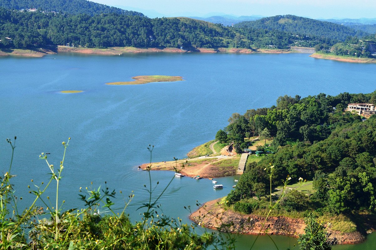
Umiam Lake
One of the most beautiful sights from Shillong Peak is Umiam Lake (also known as Barapani), a massive man-made reservoir created by damming the Umiam River. From the peak, the lake appears as a sparkling expanse of blue water surrounded by green hills, approximately 15 kilometers north of Shillong. On clear days, the water's surface reflects the sky, creating a stunning visual contrast with the surrounding verdant landscape.
Umiam Lake is not just scenic but also a major recreational hub for Shillong, with water sports, resorts, and picnic spots along its shores. From Shillong Peak, you can appreciate the lake's full extent. Read our complete guide on Umiam Lake for more details.—something impossible to grasp from ground level. Sunset views, when the lake reflects the golden-hour colors, are particularly spectacular.
Distant Himalayan Peaks
On exceptionally clear days (especially in winter when the air is crisp and visibility is maximum), you can see distant snow-capped peaks of the eastern Himalayas on the northern horizon. These include peaks in Arunachal Pradesh and possibly even parts of Bhutan. The ability to see snow-capped mountains from Meghalaya's highest point is a reminder of the broader Himalayan context of Northeast India's geography.
However, such crystal-clear days are relatively rare. Shillong Peak's name, derived from "U Shillong" (meaning "Hillof the manifestation of Leishyllong" in Khasi, referring to a deity believed to reside here), is associated with clouds. More often than not, the Himalayan views are obscured by mist and clouds.
Bangladesh Plains
Looking south from Shillong Peak, you can see the plains of neighboring Bangladesh stretching into the distance. The transition from the hills of Meghalaya to the flat plains of Bangladesh is clearly visible from this altitude. This view underscores Meghalaya's geographic position as a hill region bordering the low-lying Bengal delta.
The Bangladesh plains appear as a flat expanse extending to the horizon, with rivers winding through. On hazy days, this view can be atmospheric, with the plains fading into the distance. It's a reminder of how dramatically altitude changes in this region—from 1,966 meters at Shillong Peak to near sea level in Bangladesh just 100 kilometers south.
Rolling Khasi Hills
The most immediate and constant view from Shillong Peak is of the Khasi Hills themselves—undulating green slopes, some forested, some cultivated, stretching endlessly in all directions. Meghalaya's landscape is characterized by these hills, which are perpetually green due to abundant rainfall. From the peak, you can see:
- Pine forests: Dark green patches of pine trees planted during British colonial times.
- Traditional villages: Small settlements with tin-roofed houses scattered across the hillsides.
- Agricultural fields: Terraced fields where locals grow vegetables, potatoes, and other crops.
- River valleys: Deep valleys carved by rivers flowing through the hills.
This view gives you a sense of Meghalaya's rural beauty—the state may be known as the "Abode of Clouds," but from Shillong Peak, you can appreciate it's also an abode of endless green hills, pristine rivers, and traditional highland life.
Cloud Formations and Sunset Views
One of Shillong Peak's most magical aspects is the clouds. Meghalaya is one of the wettest places on Earth, and clouds are a constant presence here. From the peak, you can observe clouds forming below you, swirling around the hills, sometimes obscuring views and sometimes creating dramatic atmospheric scenes.
Sunset is arguably the best time to visit. As the sun descends, it paints the sky and clouds in shades of orange, pink, and gold. The clouds below you catch the last rays of light, creating a sea of gold and pink. The landscape itself transforms, with hills casting long shadows and colors changing minute by minute. Photographers will find endless inspiration during the golden hour.
Air Force Station and Restricted Areas
An important aspect of Shillong Peak that visitors need to understand is the presence of the Indian Air Force (IAF) radar station. This strategic installation is a restricted area, and not all parts of the peak are accessible to civilians.
The Radar Station
The IAF radar station at Shillong Peak is a critical component of India's air defense network in the Northeast. Given Meghalaya's proximity to international borders and the region's strategic importance, this radar installation plays a vital role in monitoring air traffic and ensuring national security.
The radar station includes:
- Radar equipment: Large rotating radar dishes visible from certain viewpoints.
- Support infrastructure: Buildings, antennas, and related facilities.
- Security perimeter: Fenced areas with restricted access.
- IAF personnel quarters: Housing for Air Force staff stationed at the peak.
What This Means for Visitors
For tourists, the IAF presence means:
- Restricted Access: You cannot roam freely over the entire peak. Access is limited to designated viewpoints and areas outside the restricted zone.
- Photography Restrictions: Photography of the radar station and related military infrastructure is prohibited. Respect these restrictions—photographing defense installations can have serious legal consequences. Focus your camera on the landscapes and views, not the radar equipment.
- Security Personnel: You'll see Air Force personnel and may encounter security checks. Be respectful, follow instructions, and carry valid ID.
- Shared Space: The peak is a unique example where civilian tourism and military installation coexist. Respect the military's need for security while enjoying the accessible areas.
Best Practices
When visiting Shillong Peak:
- Stay within designated tourist areas.
- Don't attempt to enter restricted zones or climb fences.
- Avoid photographing the radar station or military buildings.
- Carry valid identification (driver's license, voter ID, passport, etc.).
- Follow any instructions given by security personnel.
Despite these restrictions, the accessible viewpoints offer excellent views. The IAF's presence doesn't significantly detract from the experience—in fact, knowing you're at a strategic high point adds to the peak's significance.
Best Time to Visit Shillong Peak
Timing your visit to Shillong Peak can significantly impact your experience. Meghalaya's weather is highly variable, and visibility changes dramatically with seasons and time of day.
Winter (November to February)
Winter is arguably the best time for clear views. The monsoon has ended, skies are clearer, and visibility is at its maximum. Daytime temperatures are pleasant (10-20°C), though early mornings and nights can be chilly (5-10°C). This is when you have the best chance of seeing distant Himalayan peaks and enjoying uninterrupted panoramas.
Winter sunsets are spectacular, with clear skies allowing for unobstructed golden-hour views. The air is crisp, and photography conditions are ideal. However, winter can also bring occasional fog, especially in the morning, so mid-morning to afternoon visits are generally better than dawn.
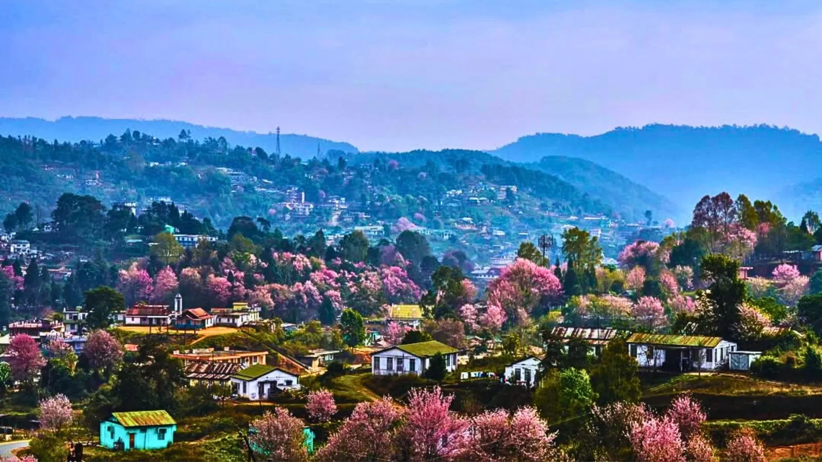
Summer (March to June)
Summer months offer pleasant weather (15-25°C) and blooming rhododendrons in the surrounding hills, adding splashes of red to the green landscape. This is peak tourist season, so expect more visitors. Skies are generally clear in the mornings, becoming cloudier in the afternoons as convectional clouds form.
For the best views, visit in the morning (9-11 AM) when visibility is typically maximum before afternoon clouds develop. Summer mornings can be magical, with the sun illuminating the landscape and relatively low humidity.
Monsoon (July to September)
Meghalaya's monsoon is legendary—Cherrapunji, just south of Shillong, is one of the wettest places on Earth. During monsoon, Shillong Peak is frequently shrouded in mist and clouds. Views are often obscured, sometimes completely. However, for some travelers, this misty, mystical atmosphere is exactly what makes Meghalaya special.
If you visit during monsoon:
- Be prepared for wet conditions—carry rain gear.
- Views may come and go as clouds shift. Patience is key.
- The landscape is lush green, having received abundant rainfall.
- Waterfalls in the surrounding hills are at their most spectacular.
- There are fewer tourists, so you may have the peak to yourself.
Time of Day
Early Morning (6-8 AM): Often the clearest time, especially in winter. Mist from the night may still be present but usually lifts as the sun rises. Morning light is beautiful for photography, and the air is cool and fresh.
Late Morning to Afternoon (10 AM-3 PM): Visibility is generally good, though clouds may develop in summer. The sun is higher, which can create harsh shadows for photography but excellent lighting for landscape shots. This is also when most tourists visit.
Sunset (4:30-6 PM, depending on season): Golden hour views are spectacular. Clouds catch the setting sun's colors, creating dramatic scenes. This is arguably the most photogenic time, though it can also be crowded. Arrive at least an hour before sunset to secure a good viewpoint.
Weather Conditions to Avoid
Avoid visiting on days with heavy rain or fog—views will be completely obscured, and the experience disappointing. Check local weather forecasts before heading out. If Shillong city is foggy, the peak will likely be even foggier.
Visitor Information: Practical Details
Before planning your visit to Shillong Peak, here's the practical information you need:
Timings
Opening Hours: Shillong Peak is typically open from 9:00 AM to 5:00 PM, seven days a week. However, these hours can vary based on weather conditions and security requirements. On days with very low visibility or heavy rain, viewpoints may close early. During winter, when sunset is earlier, plan to arrive by 3:00 PM to enjoy golden hour.
Best Time to Arrive: Mid-morning (10-11 AM) or late afternoon (3-4 PM) strikes a good balance between visibility and avoiding crowds. If photography is your priority, arrive at least an hour before sunset.
Entry Fee
There is a nominal entry fee for visiting Shillong Peak, approximately ₹20-50 per person for Indian citizens and slightly higher for foreign nationals. Fees contribute to maintenance of the viewpoint facilities. Camera fees may or may not be charged—carry some extra cash just in case.
Payment is usually accepted in cash. carry exact change as ticket counters may not always have change for large notes.
Facilities Available
- Viewing Platforms: Designated areas with railings where you can safely enjoy the views.
- Parking: Parking is available at the base of the peak, a short walk from the viewpoints. During peak season, parking can fill up, so arrive early.
- Food Options: Limited food options—there may be small stalls selling snacks, tea, and water, but don't rely on this. Carry your own water and snacks.
- Restrooms: Basic restroom facilities are available, though they may not be the cleanest. Use facilities in Shillong before your visit if possible.
- Drinking Water: Available for purchase, but it's smart to carry your own.
- Shade and Seating: Some covered areas and benches where you can rest, but these are limited.
- Safety Railings: Viewpoints have railings for safety—don't cross them for better photos.
What to Wear and Carry
Even though Shillong Peak is at a high altitude, it's accessible by road, so you don't need specialized trekking gear. However:
- Clothing: Dress in layers. It's colder at the peak than in Shillong city—typically 5-10°C cooler. A light jacket or sweater is necessary, especially in the evening. Wear comfortable walking shoes with good grip, as paths can be slippery when wet.
- Rain Gear: If visiting during monsoon, carry an umbrella or rain jacket. Weather can change quickly.
- Sun Protection: Even when it feels cool, UV radiation is strong at this altitude. Apply sunscreen and wear sunglasses.
- Water and Snacks: Carry water and light snacks. Food options are limited.
- Camera: If you're into photography, bring your camera with a wide-angle lens for landscape shots.
- Binoculars: Optional, but useful for spotting details in the expansive views.
- ID: Carry valid ID proof, as security personnel may request it.
Safety Considerations
Shillong Peak is generally safe for visitors, but keep these considerations in mind:
- Steep Drops: Some areas near viewpoints have steep drops. Stay behind railings and supervise children closely.
- Slippery Paths: Paths can be slippery when wet—walk carefully, especially during or after rain.
- Weather Changes: Weather can deteriorate quickly, especially in monsoon. If conditions become unsafe, authorities may close viewpoints. Respect these closures.
- Security Rules: Follow all security instructions. Don't enter restricted areas or photograph military installations.
How to Reach Shillong Peak
Getting to Shillong Peak is straightforward, with multiple options depending on your budget and preferences:
From Shillong City Center
The distance from Shillong city center (Police Bazaar area) to Shillong Peak is approximately 10 kilometers (6 miles). The journey takes 30-40 minutes by car, depending on traffic and road conditions.
Transport Options
Private Taxi/Car: The most convenient option. You can hire a taxi for a round trip (typically ₹800-1,500 depending on waiting time and negotiation) or use your own vehicle if you have one. Taxis are readily available in Shillong and can be booked through hotels or taxi stands.
Shared Taxi: Shared taxis may run from Shillong to Upper Shillong, from where you might need to hire another vehicle to the peak. This is the budget option but takes longer and requires transfers.
Self-Drive: If you're comfortable with hill driving, renting a car or scooter gives you flexibility. The road is well-maintained but winding and steep in sections. Drive carefully—honk on hairpin bends to alert oncoming traffic.
Organized Tours: Some tour operators in Shillong include Shillong Peak in half-day or full-day sightseeing packages. This is hassle-free but less flexible than independent travel.
Route Description
The route from Shillong to Shillong Peak typically follows this path:
- Start from Police Bazaar or your location in Shillong city.
- Head toward Upper Shillong via the main Upper Shillong Road.
- Pass through areas like Laitumkhrah and Nongthymmai.
- Look for the signposted turnoff to Shillong Peak.
- The last stretch climbs steeply to the peak entrance.
The drive is scenic, passing through pine forests, past small settlements, and offering increasingly good views as you ascend. The road is generally in good condition, though potholes can develop after monsoon. Take your time on the hairpin bends and enjoy the journey—the drive itself is part of the experience.
Parking
Parking is available at the base of the peak, a short walk from the main viewpoints. During peak season (October-May) and on weekends, parking can fill up. If parking is full, you may need to wait until a spot becomes available or park further down the road and walk up.
Nearby Landmarks
Shillong Peak is near other attractions that you can combine in a single trip:
- Elephant Falls: About 12 km from Shillong Peak, a scenic waterfall worth visiting.
- Shillong Peak Viewpoint: There are actually multiple viewpoints along the road—the main one is at the summit.
- Upper Shillong: The area around the peak has scenic spots and small villages.
Nearby Attractions
Shillong Peak is part of a broader circuit of attractions in and around Shillong. Consider combining your visit with:
Elephant Falls
Located just 12 kilometers from Shillong, Elephant Falls is one of Meghalaya's most popular waterfalls. The falls cascade down in three tiers, surrounded by lush greenery. Learn more about Elephant Falls in our detailed guide. It's an excellent spot for photography and makes a perfect combination with Shillong Peak—do the falls in the morning when they're lit by beautiful light, then head to the peak for sunset views.
Ward's Lake
Right in the heart of Shillong city, Ward's Lake (also known as Pollock's Lake) is a beautiful artificial lake surrounded by gardens. You can rent boats, stroll along the walking paths, or simply relax by the water. It's particularly pleasant in the evening when the lake is illuminated.
Shillong Golf Course
One of Asia's highest and largest natural golf courses, Shillong Golf Course is surrounded by pine and rhododendron trees. Even if you're not a golfer, the clubhouse offers excellent views, and the rolling green landscape is beautiful for a walk or photography.
Lady Hydari Park
This Japanese-style garden in Shillong is perfect for a peaceful stroll. With manicured lawns, flowers, and a small zoo, it's a family-friendly attraction that provides a contrast to the rugged natural beauty of Shillong Peak.
Don Bosco Centre for Indigenous Cultures
This fascinating museum showcases the culture of Northeast India's indigenous communities through artifacts, textiles, and displays. It's an excellent place to learn about the region's ethnic diversity and provides cultural context to your Meghalaya travels.
Shillong Peak, with its sweeping views, strategic significance, and accessible location, represents the best of Meghalaya's natural beauty. Whether you're watching clouds roll across the hills, photographing sunset gold over the landscape, or simply breathing the crisp high-altitude air, standing on Meghalaya's highest point is an experience that captures the essence of the "Abode of Clouds."
Location
Frequently Asked Questions
Q1.Where is Shillong Peak located?
Q2.What is the height of Shillong Peak?
Q3.Why is Shillong Peak famous?
Q4.What are the timings of Shillong Peak?
Q5.Is there an entry fee for Shillong Peak?
Q6.Can we visit Shillong Peak in monsoon?
Q7.What can we see from Shillong Peak?
Q8.Is Shillong Peak worth visiting?
Recommended For You
Umiam Lake Shillong: Boating, Stay Options & Sunset Views
Visit Umiam Lake (Barapani) near Shillong. Enjoy boating, water sports, resorts, picnic spots, and discover the best time to visit with our complete travel guide.
Best Time to Visit Shillong Meghalaya: Season, Rainfall & Local Events
Plan the best time to visit Shillong with season-wise weather, cherry blossom timing, monsoon travel tips, and month-by-month guidance for Meghalaya trips.
Waterfalls in Cherrapunji: 10 Best Falls with Route Details
Discover the best waterfalls in Cherrapunji including Nohkalikai, Seven Sisters, Wei Sawdong, and Dainthlen with practical route planning and season tips.
Never Miss an Adventure
Get the latest trekking guides, travel tips, and exclusive offers delivered straight to your inbox.