
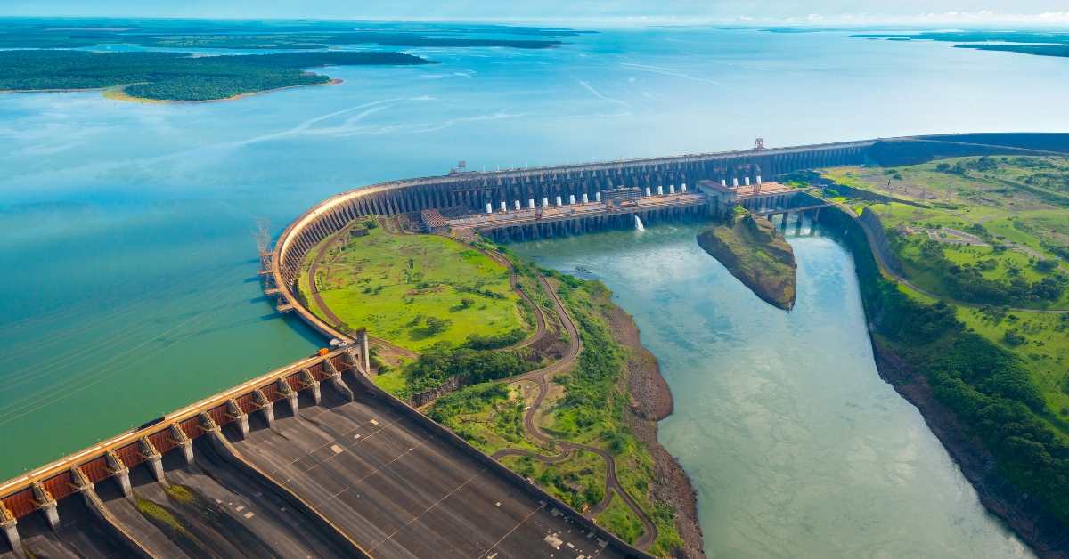
Biggest Dams in India: Guide, Routes and Travel Tips

Ananya Sharma
February 18, 2026
Explore biggest dams in India with route planning, seasonal timing, and practical travel tips for better educational and scenic visits.
Biggest Dams in India: Height, Scale, and Travel Guide
India’s largest dams are more than engineering structures. They influence irrigation, drinking water supply, hydropower generation, and regional planning at massive scale. For travelers, they also offer unique landscape experiences, from reservoir viewpoints to nearby nature routes and historical interpretation points. If you are exploring the biggest dams in India, it helps to understand both technical significance and travel practicality.
This guide gives a practical overview of major dams by scale, role, and visit planning. For destination extensions, also see bhakra nangal dam, banasura sagar dam kerala, and tandula dam chhattisgarh.

How “Biggest” is Measured
The term “biggest dam” can mean different things: highest by elevation, longest by crest length, or largest by storage capacity. This is why multiple dams may be called “largest” in different contexts. A useful approach is to compare dams by category instead of expecting a single universal ranking.
For example, one dam may dominate in height while another is famous for reservoir size or length. Understanding this distinction avoids confusion in planning and study.
Major Big Dams to Know
Tehri Dam: widely referenced for its height and hydropower importance.
Bhakra Nangal: iconic multipurpose project with historical and national significance.
Hirakud Dam: known for its long structure and major flood-control role.
Nagarjuna Sagar: critical for irrigation and water distribution systems.
Sardar Sarovar: central to large-scale water resource planning in western India.
Each project reflects a different combination of engineering objective, geography, and regional development priorities.
Top Categories at a Glance
| Category | What It Means | Why It Matters |
|---|---|---|
| Height | Vertical measure from foundation/base | Indicates engineering complexity |
| Length | Crest span across the river/valley | Reflects project scale and terrain |
| Storage Capacity | Water retained in the reservoir | Affects irrigation and supply resilience |
| Hydropower Output | Power generation potential | Supports grid and energy demand |

Why Big Dams Matter in India
Large dams support multiple public systems simultaneously: agriculture, electricity, flood management, and urban-rural water needs. In monsoon-dependent regions, stored water creates seasonal security for farming and settlements. Hydropower components add long-term energy value where terrain supports generation.
At the same time, large infrastructure requires careful environmental and social balancing. Reservoir changes can affect ecosystems, land use patterns, and settlement structures, so modern dam discussion always includes both benefits and long-term impact management.
State-Wise Presence and Distribution
Different Indian states are known for different dam profiles. Mountain states may feature height-dominant projects with hydropower orientation, while plains and plateau regions may emphasize irrigation and storage spread. This diversity reflects topography, river systems, rainfall behavior, and agricultural patterns.
If you are exploring dams as travel circuits, clustering by state or region gives better itinerary efficiency than trying cross-country one-by-one planning.
Travel and Tourism Around Dams
Many major dams are visited for scenic viewpoints, nearby gardens, eco-zones, and road-trip photography. Some locations have developed visitor infrastructure, while others are more limited and best suited for short observational stops. Always confirm local access hours and restricted zones before travel.
For smaller but useful extension ideas, consider nearby references like kasarsai dam pune and combine with regional travel themes rather than technical-only stops.

Safety and Visit Guidelines
- Follow local security rules; many dam zones have restricted areas.
- Avoid unsafe edge photography, especially in windy or wet conditions.
- Respect signage regarding no-entry operational sectors.
- Plan daytime visits; infrastructure zones may not be ideal after dark.
- Carry water and essentials, as amenities can vary by location.
Dam visits are most enjoyable when planned as part of a broader regional itinerary with nature, culture, or city segments.
Future of Large Dam Infrastructure
Future development conversations increasingly focus on modernization, safety upgrades, better reservoir management, and climate-linked planning. Many existing projects are being reviewed for improved operational efficiency and long-term resilience. Water planning is now tied more closely to extreme-weather adaptation and downstream ecosystem monitoring.
This shift makes dam infrastructure an evolving subject rather than a static list of historical projects.
Suggested 4-Day Themed Circuit Approach
Day 1: primary dam site and interpretation viewpoint.
Day 2: nearby reservoir and local ecology/culture stop.
Day 3: second infrastructure or river-basin reference point.
Day 4: flexible buffer and return segment.
Planning this way improves depth and reduces long-distance fatigue.

Final Takeaway
The biggest dams in India represent a mix of engineering scale, development strategy, and regional dependency on managed water systems. Whether you approach them for study or travel, compare by category, plan safely, and pair infrastructure visits with broader destination context for a more meaningful experience.
How to Read Dam Data Correctly
When comparing major dams, always check what metric is being discussed: height, length, storage, or generation capacity. Headlines often mix these terms, which creates confusion. A technically correct comparison should mention both structural and functional context. For instance, a dam with moderate height can still be strategically vital because of reservoir function and irrigation footprint.
Also consider project purpose. Some dams prioritize power, some prioritize irrigation, and many are multi-purpose. Understanding intent helps interpret why one project matters more in one region and another elsewhere.
Planning Educational or Travel Visits
If you are visiting dam regions for learning or travel content, combine technical context with local geography. Read up on basin history, nearby settlements, and public access rules before arrival. Many travelers improve visit quality by pairing dam viewpoints with nearby museums, eco-zones, and cultural sites rather than treating the structure as a one-stop photo point.
For safer and better field visits, avoid monsoon-heavy windows in vulnerable areas, carry essentials, and follow all restricted-zone rules strictly.
Responsible Infrastructure Tourism
When visiting dam regions, treat the location as critical infrastructure first and a scenic point second. Respect all restricted markers, avoid intrusive behavior near operations, and follow local authority directions. Many sites are important for regional safety and utility continuity, so responsible travel conduct matters.
For educational travelers, combine pre-reading with on-site observation. Understanding basin context, rainfall dependence, and regional usage makes each visit far more meaningful than a quick viewpoint stop. This approach turns dam travel into a stronger learning experience and supports informed conversations around water management in India.
Location
Frequently Asked Questions
Q1.How to plan visits to major dams in India?
Q2.Does season affect dam visits?
Q3.Is this suitable for educational travel?
Q4.Can I combine with nearby sightseeing?
Q5.Should I check local rules?
Q6.How much time should I keep?
Q7.What improves visit quality?
Q8.Is family travel possible?
Recommended For You

Best Party Destinations in India for Christmas & New Year
Find India’s top party destinations for Christmas and New Year with practical planning, crowd strategy, and safety-focused travel tips.
Best Snow Destinations India for Christmas and New Year
Discover India’s best snow destinations for Christmas and New Year with route planning, timing strategy, and practical winter-travel tips.
Kasarsai Dam Pune: Boating, Camping Spots & Weekend Plan
Visit Kasarsai Dam near Pune! Discover best time to visit, picnic spots, boating, camping, how to reach, activities & complete weekend getaway guide.
Never Miss an Adventure
Get the latest trekking guides, travel tips, and exclusive offers delivered straight to your inbox.
