
Sinthan Top Kashmir: Complete Guide, Route & Best Time 2026
Rohit Verma
January 17, 2026
Complete Sinthan Top Kashmir guide featuring route from Srinagar/Pahalgam, best time to visit, trekking options, weather, and travel tips for 2026.
Sinthan Top Kashmir: Route Conditions, Altitude Planning, and Scenic Drive Guide
Sinthan Top is one of Kashmir’s most visually rewarding mountain-pass drives, known for high-altitude views, changing weather moods, and dramatic road transitions. The biggest planning error is treating it like a short city viewpoint. This route needs timing discipline, altitude awareness, and safe return margins. If you are building a larger Kashmir itinerary, connect Sinthan with Kashmir travel guide, seasonal windows from best time to visit Kashmir, nearby alternatives like Bangus Valley, and lake-side recovery options such as Surinsar Lake. This guide focuses on practical route strategy so your day stays scenic and safe.
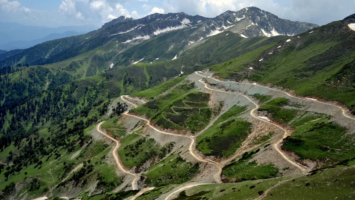
What Makes Sinthan Top Special
The attraction is the road-to-viewpoint transition. As you gain elevation, terrain character changes quickly: valley greens, open ridges, and high-pass visual drama. This dynamic route profile is what makes Sinthan popular among road-trippers and photographers.
Best Time to Visit
The ideal window depends on road opening and weather stability. Clear-season travel usually offers better visibility and smoother movement, while shoulder periods may deliver dramatic atmosphere with higher uncertainty. Always verify road condition close to departure.
| Condition | Travel Quality | Advice |
|---|---|---|
| Clear weather | Best views and safer pacing | Start early, keep photo buffers |
| Cloud build-up | Moody visuals, reduced visibility | Avoid late-risk pushes |
| Unstable weather | Rapid condition changes | Reduce scope and return early |
How to Reach and Plan the Drive
Use experienced drivers for unfamiliar mountain sections. Keep fuel, food, and emergency basics arranged before entering long stretches with limited support. Avoid aggressive multi-stop planning around high-pass timelines.
- Fix turnaround time before departure.
- Carry warm layers even in mild-start days.
- Download offline navigation backups.
- Avoid post-sunset mountain driving.
Altitude and Comfort Tips
Even short halts at high points can feel physically demanding. Hydrate consistently, move slowly, and avoid overexertion for photos. If symptoms such as headache or breath discomfort increase, descend and rest instead of forcing extra stopovers.
Photography Strategy at Sinthan
Use one wide frame for ridge scale and one mid-frame for road-depth storytelling. Early and late light produce better terrain contrast than flat midday. Keep your camera or phone secure in wind-prone sections and avoid unstable edge positions.
How to Pair Sinthan with Other Kashmir Stops
Sinthan is best as a primary drive day plus one light secondary stop. For multi-day plans, use Kashmir route guides and keep one lower-intensity day after high-pass travel. Nature-focused travelers can compare with Bangus Valley or relax with Surinsar Lake on a separate day.
Common Mistakes to Avoid
- Starting late and driving back in low light.
- Ignoring real-time road/weather updates.
- Packing too many far stops in one day.
- Skipping altitude hydration and warm layers.
- Prioritizing speed over road safety.
Final Takeaway
Sinthan Top Kashmir delivers high visual value when planned as a disciplined mountain-drive day. Keep early starts, weather buffers, and conservative return timing at the center of your itinerary.
The right strategy turns this into one of Kashmir’s best road-view experiences.
Safety-first planning improves both photos and trip comfort.
In high-pass travel, controlled pacing is the real advantage.
High-Pass Driving Discipline
Sinthan Top is a scenic destination, but route discipline is the real success factor. Keep speed conservative, plan controlled photo halts, and avoid late-day risks. If visibility drops, reduce stop frequency and prioritize safe return. High-pass trips reward calm judgment, not aggressive itinerary targets.
Weather Buffer Model
Use a simple model: one primary stop window, one optional stop window, one emergency buffer. If weather remains stable, you use optional stop. If weather degrades, you use emergency buffer for safe descent. This model keeps decision quality high under uncertainty.
- Start with full fuel and basic emergency kit.
- Carry warm layers even in sunny starts.
- Avoid edge photography in strong wind.
- Set a fixed descent cutoff time.
Final Planning Principle
Sinthan Top gives its best experience when your route is conservative and your timing is strict. Protect the return window and the day will stay scenic, safe, and memorable.
Extended Planning Playbook
Strong travel outcomes usually come from preparation habits, not from adding more destinations. Use a layered plan before departure: define one primary objective, one secondary objective, and one fallback option. The primary objective is what makes the day worthwhile even if weather or delays affect everything else. The secondary objective is optional and should be dropped quickly if timing slips. The fallback option should be low-risk and close to your route so you can still have a meaningful day without forcing difficult movement. This structure reduces stress and protects experience quality.
Next, map your day in realistic blocks rather than exact minute-by-minute promises. A practical approach is to assign 90-120 minute activity blocks with 20-30 minute transition buffers. Most travelers skip buffers and then rush decisions late in the day. Buffer time is not wasted time; it is decision margin. It allows for weather delays, traffic shifts, short rest stops, or queue variation without breaking the entire plan. Trips feel smoother when flexibility is built in from the start.
On-Ground Execution Rules
Once on site, run a simple three-step check before every major movement: current weather, group energy, and daylight margin. If any of these are weak, reduce scope immediately. This is the most effective way to prevent avoidable risk. Travelers often keep original plans even when conditions change, and that creates rushed exits and lower-quality experiences. Smart travel means adapting early, not reacting late.
- Hydrate at regular intervals instead of waiting for fatigue signs.
- Keep food simple and energy-stable to avoid long unplanned breaks.
- Maintain one clear group communication rule for movement timing.
- Protect return schedules, especially in low-support or mountain routes.
- Use conservative decision-making when weather uncertainty appears.
Budget and Comfort Controls
Good itineraries also control hidden costs. Carry essential basics so you are not forced into overpriced last-minute purchases. Keep a small contingency budget for transport changes and safety-driven rerouting. Comfort planning matters too: appropriate footwear, light weather layers, and power backup improve decision quality throughout the day. Small discomforts become major problems when combined with long transit and shifting weather.
Content and Photography Balance
If you are capturing photos or video, separate documentation from exploration. Spend the first pass understanding the place, and the second pass creating content. This prevents rushed, repetitive shots and reduces unsafe positioning choices. The best travel content usually comes from patient observation rather than constant motion. When the environment is dynamic, a stable viewpoint often gives better results than frequent location switching.
Post-Visit Reset
End each day with a short reset: hydrate, review what worked, and simplify the next day’s plan based on real conditions. This keeps multi-day itineraries sustainable. Travelers who do quick daily resets make better choices and avoid cumulative fatigue. The goal is not maximum checklist completion, it is high-quality, safe, and memorable travel across the full trip.
A practical pass-day rule is simple: if visibility drops and timing is tight, descend early. Keeping this discipline improves both safety and overall route success.
Route discipline and daylight awareness should always guide your final descent decisions.
Always preserve enough daylight margin for an unhurried descent.
Plan your summit halt, photo block, and descent order before arrival so that changing mountain weather does not force rushed decisions during the most safety-critical part of the day.
Location
Frequently Asked Questions
Q1.Where is Sinthan Top located in Kashmir?
Q2.What is the best time to visit Sinthan Top?
Q3.How do I reach Sinthan Top from Srinagar?
Q4.Is Sinthan Top safe to visit?
Q5.What can I do at Sinthan Top?
Q6.What accommodation is available near Sinthan Top?
Q7.How much time should I keep for Sinthan Top trip?
Q8.What should I pack for Sinthan Top?
Recommended For You
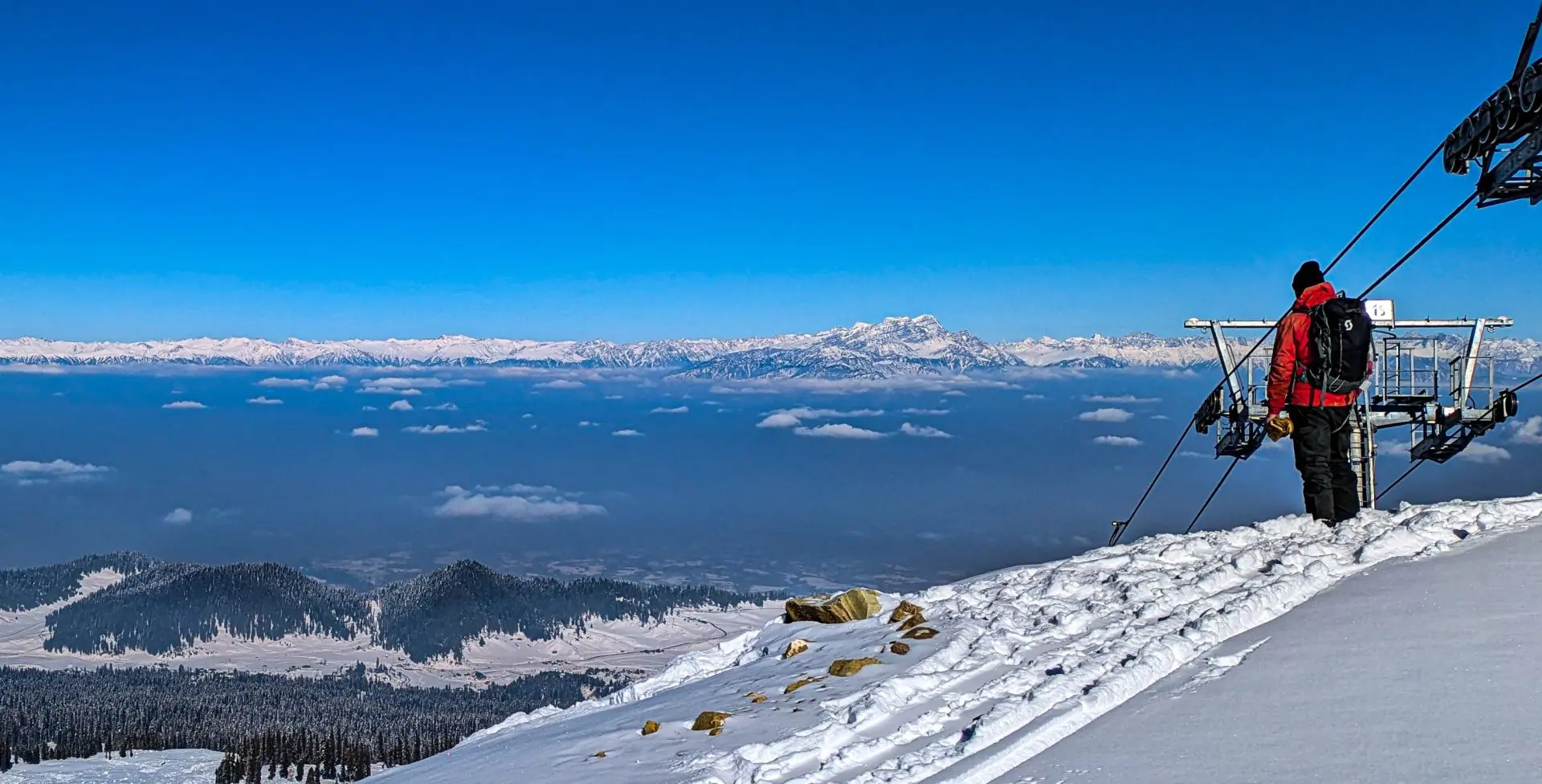
Skiing in Gulmarg: Complete Guide, Prices & Best Season 2026
Complete skiing Gulmarg guide featuring gondola prices, best season, lessons, equipment rental, accommodation, and travel tips for 2026.
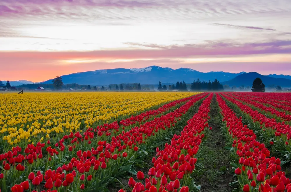
Kashmir Tulip Garden: Timings, Ticket Price & Season
Visit Asia's largest Kashmir Tulip Garden! Get best time to visit, ticket prices, opening timings, tulip festival dates & complete travel guide for Srinagar.
Never Miss an Adventure
Get the latest trekking guides, travel tips, and exclusive offers delivered straight to your inbox.