Spiti River: The Lifeline of the Cold Desert
Rahul Garg
January 5, 2026
Spiti River: Complete guide to the lifeline of Spiti Valley - rafting, monasteries, geography, best time to visit & cultural significance in the cold desert.
Introduction: The River that Flows from the Middle Land
The Spiti River, originating from the Kunzum Range and flowing through the heart of Himachal Pradesh's remote Spiti Valley, is one of India's most spectacular yet least explored rivers. Its name, derived from the Tibetan word "Spiti" meaning "the middle land," perfectly describes its location - a land between Tibet and India, between the Himalayan and Zanskar ranges. The Spiti River is not merely a water body but the very lifeline of this cold desert, nurturing civilizations, creating breathtaking landscapes, and offering adventures that etch themselves into memory. For those planning a Himachal Pradesh adventure, this river offers an experience unlike any other in the state.
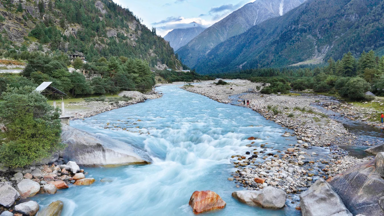
Flowing for approximately 240 kilometers through some of the most rugged and remote terrain in the Indian Himalayas, the Spiti River creates a stunning contrast between its turquoise waters and the barren, multi-colored mountains that rise dramatically from its banks. This high-altitude desert river, flowing at an average elevation of over 3,600 meters (11,800 feet), is a testament to nature's raw power and beauty. Whether you're an adventure seeker looking to raft its rapids, a spiritual seeker drawn to its tranquil valleys, or simply someone in awe of natural landscapes, the Spiti River offers experiences found nowhere else on Earth.
Geography and Origin
The Spiti River's journey is as fascinating as the landscapes it creates.
Source and Course
The Spiti River originates from the Kunzum Pass area at an elevation of approximately 4,500 meters (14,750 feet). Its main source is the glaciers of the Kunzum Range, particularly the Kunzum Glacier and several smaller glaciers in the surrounding peaks. From its source, the river flows southeast through the Spiti Valley, passing by ancient monasteries, traditional villages, and dramatic geological formations. The region is also home to the magnificent 8-day Spiti Valley trip that many travelers embark on to explore this remote paradise.
The river is joined by numerous tributaries along its course, including the Pin River, the Lingti River, and the Parahio River. Each tributary brings water from different valleys and glaciers, contributing to the Spiti's flow and creating a complex river system that sustains life in this harsh environment.
At Sumdo, the Spiti River merges with the Satluj River, which continues its journey into the plains of Punjab. The confluence is a significant geographical point, marking the end of the Spiti Valley and the transition from the high Himalayas to the lower ranges.
Geological Significance
The Spiti River has played a crucial role in shaping the geology of the Spiti Valley. Over millions of years, its waters have carved through sedimentary rock layers, exposing one of the world's most complete geological sequences from the Paleozoic era. The river's erosional power has created deep gorges, steep cliffs, and dramatic canyons that reveal rock formations dating back over 500 million years.
The region is renowned among geologists and paleontologists for its fossil-rich rocks, particularly in the villages of Lalung and Malling. The Spiti River has exposed these fossil beds, making them accessible for study and viewing. The river valley contains one of the world's most continuous sequences of fossils from the Cambrian to the Cretaceous periods, making it a living museum of Earth's history.
Glacial-fed System
Like most Himalayan rivers, the Spiti is primarily glacial-fed, meaning its flow depends heavily on snowmelt and glacial melt. This creates unique seasonal variations:
- Spring (April-May): Minimal flow as snow begins to melt
- Summer (June-August): Maximum flow as snow and glaciers melt rapidly
- Autumn (September-October): Decreasing flow as temperatures drop
- winter (November-March): Minimal flow, with sections partially freezing
Cultural and Spiritual Significance
The Spiti River is deeply woven into the cultural and spiritual fabric of the Spiti Valley.
Ancient Civilizations Along its Banks
The Spiti River has nurtured human settlements for thousands of years. Ancient villages like Kaza, Tabo, Dhankar, and Ki all grew along its banks, drawn by the reliable water source in an otherwise arid landscape. These villages developed sophisticated irrigation systems called "Kuls" that channel water from the Spiti and its tributaries to agricultural fields, enabling farming in this cold desert.
The traditional Spitian way of life revolves around the river's rhythm. Agriculture is timed with the spring thaw, when water first becomes available for irrigation. Festivals celebrate the river's life-giving properties. Even the architecture of traditional Spitian homes reflects the need to manage water efficiently in this harsh environment.
Buddhist Monasteries and the River
The Spiti River is intimately connected to Buddhism in the valley. Many of Spiti's most important monasteries are strategically positioned overlooking the river, as if the monks drew spiritual sustenance from its waters:
Tabo Monastery: Known as the "Ajanta of the Himalayas" for its exquisite wall paintings, Tabo sits on the left bank of the Spiti. Founded in 996 AD, it's one of the oldest continuously operating Buddhist enclaves in India.
Dhankar Monastery: Perched dramatically on a cliff overlooking the confluence of the Spiti and Pin Rivers, Dhankar's location symbolizes the union of wisdom and compassion. The view of the rivers from the monastery is considered auspicious.
Ki Monastery: While not directly on the riverbank, Ki commands a view of the entire Spiti Valley, with the river winding through the landscape below. Monks from Ki have traditionally performed rituals to protect the valley and its water sources.
Monks from these monasteries perform "Cham" dances and rituals that honor nature's elements, including water. The river is seen not just as a physical resource but as a sacred entity worthy of respect and protection.
The River as a Teacher
In Tibetan Buddhism, rivers symbolize the flow of life, the impermanence of all things, and the path to enlightenment. The Spiti River, with its origins in pure glacial ice, its journey through challenging terrain, and its ultimate merging with the Satluj, serves as a powerful metaphor for spiritual practice. Locals and monks alike speak of the river's teachings - its persistence in flowing around obstacles, its clarity when undisturbed, and its power when accumulated.
Adventure Activities on the Spiti River
For adventure enthusiasts, the Spiti River offers thrilling experiences in one of the world's most spectacular settings.
River Rafting
Rafting on the Spiti River is an adventure like no other, combining challenging rapids with breathtaking scenery. The rafting season typically runs from June to September when water levels are highest and weather conditions are most favorable.
Popular Rafting Routes:
Kaza to Sumdo: The most common and accessible route, covering approximately 60-70 kilometers over 2-3 days. This section offers Grade II-III rapids suitable for beginners and intermediates, with spectacular views of the valley and villages.
Pin River to Kaza: A shorter route (approximately 30-40 km) that includes the confluence of the Pin and Spiti Rivers. Offers Grade II-III rapids and beautiful scenery.
Advanced Expeditions: For experienced rafters, longer expeditions covering 100+ kilometers over 4-5 days are possible, including remote sections with Grade III-IV rapids.
What Makes Spiti Rafting Special:
- High Altitude: At 3,600+ meters, this is among the highest rafting experiences anywhere
- Remote Wilderness: The rafting route passes through pristine landscapes with little human presence
- Cultural Experience: Pass by ancient monasteries, traditional villages, and chortens
- Unique Terrain: The contrast between the turquoise river and barren mountains is spectacular
Rafting Operators and Costs:
Several operators run rafting expeditions on the Spiti. Costs typically range from INR 3,000-6,000 per person for day trips and INR 12,000-25,000 for multi-day expeditions, including equipment, guides, camping, and meals. Popular operators include Spiti Valley Adventure, Himalayan Caravan Adventure, and various Manali-based agencies.
Challenges and Considerations:
- Altitude can be challenging - acclimatize properly before attempting rafting
- Water temperature is near-freezing - wetsuits are essential even in summer
- Rapid classification can change with water levels - always follow guide instructions
- Remote location means evacuation is difficult if accidents occur
- Weather can change quickly - be prepared for cold, rain, and sun
Fishing (Catch and Release)
The Spiti River is home to the endangered Snow Trout and Brown Trout, making it an attractive destination for anglers. However, fishing is highly regulated:
- Only catch-and-release fishing is permitted
- Fishing licenses are required from the Himachal Pradesh fisheries department
- Fishing is allowed only in designated stretches
- The season typically runs from April to October
- Local guides are recommended, both for knowledge and regulation compliance
Fishing in the Spiti is less about the catch and more about the experience of casting a line in a pristine Himalayan river surrounded by 6,000-meter peaks. The solitude and scenery make it a uniquely peaceful activity.
Best Time to Visit the Spiti River
The Spiti River and valley are accessible only for a few months each year, and timing your visit is crucial.
Season Guide
Summer (June to August): The peak season and best time for most activities. Days are warm (15-25°C), nights are cool (5-10°C), and the river is at its fullest from glacial melt. Roads are generally accessible, and all facilities are open. This is the best time for rafting, trekking, and general sightseeing. However, it's also the busiest time with the most tourists. If you're wondering about the best time to visit Spiti Valley, summer offers the most accessible conditions for exploration.
Autumn (September to October): An excellent time to visit. Crowds thin out significantly, temperatures remain pleasant (10-20°C days, 0-5°C nights), and the landscape takes on beautiful autumn colors. The river's flow decreases, revealing more of its banks. This is ideal for photographers, those seeking tranquility, and travelers who prefer fewer crowds. However, facilities may begin closing by late October as winter approaches. Many travelers also enjoy camping in Spiti Valley during this peaceful season.
Winter (November to March): The Spiti Valley is largely cut off during winter. Kunzum Pass closes, making overland access impossible from the north. The Spiti River partially freezes in many sections, creating surreal ice formations. Only the hardiest travelers visit during this time, typically from Shimla via the Hindustan-Tibet Road, which remains open but challenging. Temperatures plummet to -20°C or below. Most facilities close. This is for the truly adventurous seeking an extreme cold desert experience.
Spring (April to May): The valley slowly awakens from winter. Snow melts, the Spiti begins to flow more freely, and temperatures gradually rise (5-15°C days, -5 to 5°C nights). Roads from Shimla usually open by May, but Kunzum Pass may remain closed until mid-June. Spring is ideal for avoiding crowds, witnessing the valley's renewal, and experiencing Spiti before the tourist rush. Some facilities may have limited operations.
Month-by-Month Breakdown
- June: Access opening from Manali side. River flow increasing. Good weather.
- July: Peak season. Warm days. River at full flow. Best for rafting.
- August: Peak season continues. Risk of landslides due to monsoon.
- September: Fewer crowds. Pleasant weather. Decreasing river flow.
- October: Last month before winter closures. Beautiful autumn colors.
Key Locations Along the Spiti River
The Spiti River flows past some of Spiti Valley's most important and beautiful locations.
Kaza
Altitude: 3,650 meters (11,975 feet)
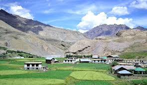
Kaza is the largest town in Spiti Valley and sits directly on the banks of the Spiti River. It serves as the region's administrative center and main base for travelers. The river flows through the town, creating a pleasant riverside atmosphere. Kaza has accommodation options, restaurants, fuel stations, ATM facilities, and medical services - all essential for travelers. The old town (Kaza Khas) and new town (Kaza Soma) are on opposite sides of the river, connected by a bridge.
Tabo
Altitude: 3,050 meters (10,006 feet)
Tabo, home to the famous Tabo Monastery (a UNESCO World Heritage Site tentative list), sits on the left bank of the Spiti River. The river here is calmer, having descended from the higher reaches of the valley. The town is one of the oldest continuously inhabited settlements in Spiti, with the monastery dating back to 996 AD. The combination of the ancient monastery, traditional mud-brick houses, and the flowing river creates a timeless atmosphere.
Dhankar
Altitude: 3,894 meters (12,777 feet)
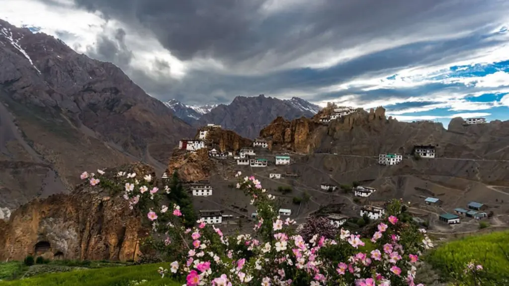
Perched dramatically on a cliff overlooking the confluence of the Spiti and Pin Rivers, Dhankar is perhaps the most spectacularly located village in Spiti. The old Dhankar Monastery, built on the edge of a precipice, offers panoramic views of both rivers below. The confluence creates a beautiful contrast between the Spiti's turquoise waters and the Pin's silt-laden flow. A new Dhankar Monastery has been built in the village below, as the old one faces structural instability from erosion.
Ki
Altitude: 4,116 meters (13,501 feet)
Ki is home to the famous Ki Monastery, the largest in Spiti Valley. While the monastery sits on a hill above the river, the village of Ki is in the valley below, along the Spiti River. From the monastery, one can see the Spiti winding through the valley floor, creating a silver ribbon against the brown mountains. The area around Ki offers some of the best views of the Spiti River's course through the valley.
Sumdo
Altitude: 2,970 meters (9,744 feet)
Sumdo, at the confluence of the Spiti and Satluj Rivers, marks the end of the Spiti Valley and the beginning of the Satluj Valley. This is where the Spiti River ends its journey through its namesake valley and joins the larger Satluj River. The confluence is a significant geographical point and offers beautiful views of both rivers merging. Sumdo is also the gateway to the Tabo area and has a border checkpost where foreign travelers must register.
Sichling
Altitude: 3,400 meters (11,155 feet)
A small village on the banks of the Spiti between Kaza and Tabo, Sichling is known for its pebble beaches along the river. During summer, when water levels recede slightly, beautiful pebble beaches emerge along the riverbanks. These beaches offer camping opportunities and a surreal experience - sitting by a glacial river on a pebble beach surrounded by towering Himalayan peaks.
Flora and Fauna of the Spiti River Ecosystem
Despite its harsh conditions, the Spiti River ecosystem supports surprising biodiversity.
Aquatic Life
The Spiti River and its tributaries support several fish species adapted to cold, high-altitude waters:
Snow Trout: The most common species, found throughout the Spiti and its tributaries. These fish have adapted to near-freezing waters and fast currents.
Brown Trout: Introduced during British times, Brown Trout have established populations in some sections. They're highly prized by anglers for their fighting spirit.
The river's water quality is exceptionally pure, fed by glacial melt with minimal pollution. However, fish populations are under pressure from overfishing, habitat degradation, and climate change affecting glacial melt patterns.
Riparian Vegetation
The vegetation along the Spiti River's banks is sparse but specially adapted:
Sea Buckthorn: A thorny shrub with bright orange berries that grows along riverbanks. The berries are rich in nutrients and used in local foods and medicines. Sea buckthorn helps prevent soil erosion along riverbanks.
Willow and Poplar: These trees are planted along the river, especially near villages. They provide shade, windbreaks, and material for construction.
Wild Roses: Found along the river, especially in lower altitude sections near Tabo. The rose hips are used for teas and jams.
Alpine Grasses: Various grass species grow along the banks, providing grazing for livestock and helping stabilize the soil.
Wildlife Dependent on the River
Many species rely on the Spiti River for water:
Blue Sheep: Often seen descending to drink from the river, especially in winter when other water sources freeze.
Himalayan Ibex: These sure-footed goats navigate steep cliffs above the river and come down to drink.
Snow Leopard: The elusive Snow Leopard preys on animals that come to drink. The river corridor creates a natural hunting ground.
Tibetan Wolf: Wolves follow the river valley, using it as a travel corridor and hunting ground.
Avian Life: Various bird species are found along the river, including the Brown Dipper (which dives underwater), Plumbeous Water Redstart, and migratory birds that use the river as a flyway.
Threats and Conservation
The Spiti River, like many Himalayan rivers, faces several threats.
Climate Change
Climate change is the most significant threat to the Spiti River:
- Glacial Retreat: The glaciers that feed the Spiti are retreating, which could initially increase flow but ultimately decrease the river's long-term water supply.
- Changing Monsoon Patterns: Increasing monsoon rainfall in traditionally arid Spiti causes more frequent flash floods and landslides.
- Temperature Rise: Warmer temperatures alter the ecosystem, affecting fish, vegetation, and wildlife adapted to cold conditions.
- Glacial Lake Outburst Floods (GLOFs): Retreating glaciers form unstable lakes that can burst, causing devastating floods downstream.
Hydroelectric Projects
Several hydroelectric projects are planned or under construction on the Spiti and its tributaries. While these projects bring development, they also:
- Alter natural flow regimes
- Disrupt aquatic ecosystems
- Require construction in fragile environments
- Impact traditional water management systems
Balancing development needs with conservation is a critical challenge for Spiti's future.
Tourism Pressure
Increasing tourism brings economic benefits but also environmental pressures:
- Pollution from increased human activity
- Water withdrawal for tourist facilities
- Disturbance of wildlife
- Erosion from off-road driving
Conservation Efforts
Several organizations are working to protect the Spiti River ecosystem:
- Snow Leopard Conservancy India Trust: Works to protect Snow Leopard habitat, which includes protecting the river ecosystem.
- Spiti Seabuckthorn Society: Promotes cultivation of seabuckthorn to prevent erosion and provide livelihoods.
- Kaza's Ecosphere: A social enterprise working on sustainable tourism and conservation.
- Local Monasteries: Buddhist monasteries promote environmental stewardship as part of spiritual practice.
Tips for Visiting the Spiti River
Permits and Documentation
Indian Nationals: No special permits required for most of Spiti Valley. However, Inner Line Permits may be needed for certain areas near the border with Tibet. Check current requirements.
Foreign Nationals: Inner Line Permits are required for Spiti Valley. These can be obtained in Reckong Peo, Kaza, or Shimla. The permit typically costs INR 200-500 and requires passport photos and photocopies of your passport and visa. Permits are valid for a specific period and cover specific areas.
Acclimatization
The Spiti River valley is at high altitude, and proper acclimatization is essential:
- Spend at least 2-3 nights at an intermediate altitude (2,000-3,000 meters) before ascending
- Stay hydrated but avoid alcohol
- Ascend gradually - don't rush from Manali to Kaza in one day
- Recognize AMS symptoms - headache, nausea, dizziness, shortness of breath
- Descend if symptoms worsen - AMS can be fatal if untreated
Packing Essentials
- Clothing: Layers are essential. Temperatures vary dramatically between day and night. Include thermal underwear, fleece jacket, down jacket, warm hat, gloves, and sturdy hiking boots.
- Sun Protection: UV radiation is intense at altitude. Bring high SPF sunscreen, sunglasses, and a wide-brimmed hat.
- Water Purification: While the Spiti's water is clean, it's safer to purify. Bring purification tablets or a filter.
- First Aid: Include AMS medication (Diamox), basic first aid supplies, and any personal medications.
- Cash: ATMs are only in Kaza and don't always work. Carry sufficient cash.
Responsible Travel
- Take all trash back with you - the Spiti Valley has limited waste management
- Use established campsites rather than creating new ones
- Respect local customs - ask before photographing people or religious sites
- Support local businesses - homestays, local guides, and artisans
- Conserve water - it's a precious resource in this desert
The Spiti River: A Journey Through Time
The Spiti River is more than a geographic feature - it's the living heart of Spiti Valley, the thread that weaves together landscape, culture, and life. From its glacial origins high in the Kunzum Range to its confluence with the Satluj at Sumdo, the Spiti River tells stories of ancient civilizations, spiritual traditions, geological wonders, and remarkable adaptations to life at the edge of what's possible.
For the traveler who makes the journey to this remote corner of the Himalayas, the Spiti River offers rewards that extend far beyond typical tourist experiences. Whether watching its turquoise waters wind through barren mountains from a monastery high above, navigating its rapids on a rafting expedition, or simply sitting by its banks listening to its timeless flow, the Spiti River has a way of changing those who experience it.
In our fast-paced modern world, places like the Spiti River valley remind us of nature's grandeur, humanity's smallness, and the enduring power of landscapes shaped over millennia. The river teaches us about persistence, about flowing around obstacles rather than fighting them, about clarity that comes from pure sources, and about the journey being as important as the destination.
As climate change and development threaten pristine places around the world, the Spiti River stands as both a treasure to protect and a teacher to learn from. Its future will be determined by the choices we make today - to visit responsibly, to support conservation efforts, and to recognize that some places are too special to be sacrificed for short-term gains.
The Spiti River flows through the middle land, but it touches the deepest parts of those who experience it. May it continue to flow, pure and powerful, for generations to come.
Location
Frequently Asked Questions
Q1.Where does the Spiti River originate from?
Q2.Can you do river rafting in the Spiti River?
Q3.What is the best time to visit Spiti River?
Q4.How long is the Spiti River?
Q5.What fish are found in the Spiti River?
Q6.What are the major monasteries along the Spiti River?
Q7.Is Inner Line Permit required for Spiti River area?
Q8.How cold is the Spiti River water?
Recommended For You
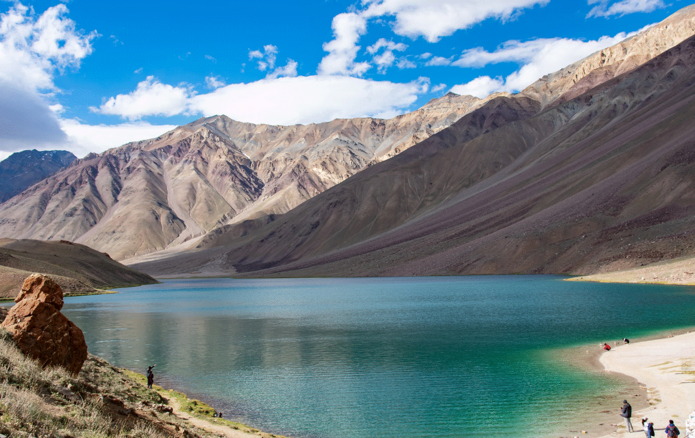
Chandratal Lake: Trek Route Best Time And Packages
Plan Chandratal Lake Spiti with Manali/Kaza routes, road-window months, camping rules, altitude tips, and practical trekking guidance for a safe trip.
Spiti in October: Travel Guide & Tips
Spiti in October: Complete guide to weather, road conditions, things to do, photography tips & why it's the perfect time to visit the cold desert.
Pin Valley National Park Spiti: Wildlife, Trek Routes & Travel Tips
Pin Valley National Park complete guide covering wildlife, snow leopard habitat, treks, best season, route planning from Kaza, permits, and practical stay tips in Spiti.
Never Miss an Adventure
Get the latest trekking guides, travel tips, and exclusive offers delivered straight to your inbox.