Leh to Changthang Bike Trip: Route & Itinerary
Ananya Sharma
December 16, 2025
Ultimate guide to Leh to Changthang bike trip. Route via Hanle, Tso Moriri, Tso Kar. Itinerary, road conditions, permits & preparation.
Introduction: The Remote Changthang
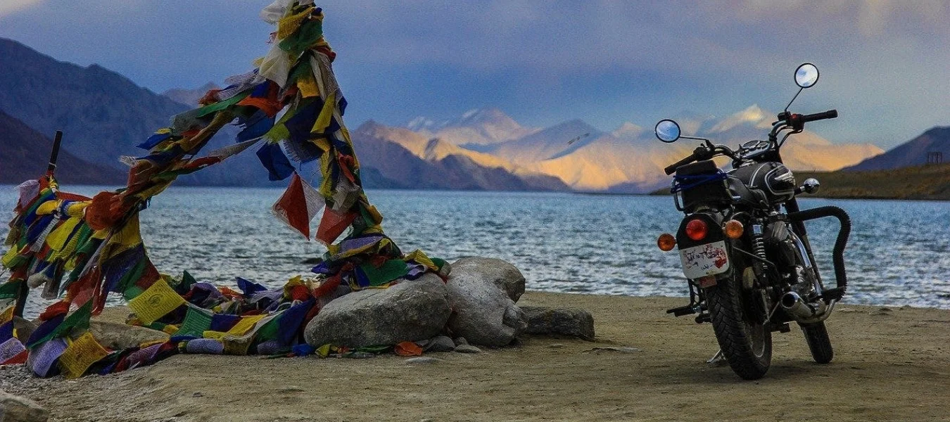
A bike trip from Leh to Changthang represents one of the most remote and rewarding journeys possible in Ladakh. The Changthang plateau, stretching across eastern Ladakh, and bordering Tibet, is a high-altitude desert landscape that feels like another planet. For more bike adventure planning,. This is a land where nomadic Changpa herders have tended their yak and pashmina goat herds for centuries, where pristine lakes reflect snow-capped peaks, and where the horizon seems to stretch infinitely.
Unlike the well-trodden routes to Pangong Lake and Nubra Valley, the Changthang circuit takes you into genuine wilderness. Roads here are rough, settlements are few, and mobile connectivity is virtually non-existent. In return, you'll experience Ladakh at its most raw and authentic - vast open spaces, wildlife sightings, and a profound silence that's increasingly rare in our modern world.
About Changthang Valley
The Changthang plateau is a high-altitude desert averaging 4,000-5,000 meters above sea level. This region is characterized by its stark beauty - treeless plains framed by jagged mountains, dotted with azure lakes that seem too blue to be real. The extreme altitude and harsh climate mean that only specially adapted wildlife and hardy human communities can survive here.
Geography and Landscape
Changthang stretches from the southeast of Ladakh into Tibet. The landscape is defined by its altitude - one of the highest inhabited places on Earth. The plateau is dotted with salt lakes, including Tso Moriri and Tso Kar, which are among the highest lakes in the world. The region is also home to hot springs, particularly at Chumathang, where warm water emerges from the earth in the freezing landscape.
The terrain is primarily rolling plains interspersed with mountain passes. Roads cut through this landscape, mostly unpaved, following valleys and crossing passes. The riding surface varies from good paved sections to rocky tracks that demand careful navigation. In some areas, river crossings add excitement and challenge to the journey.
Changpa Nomads
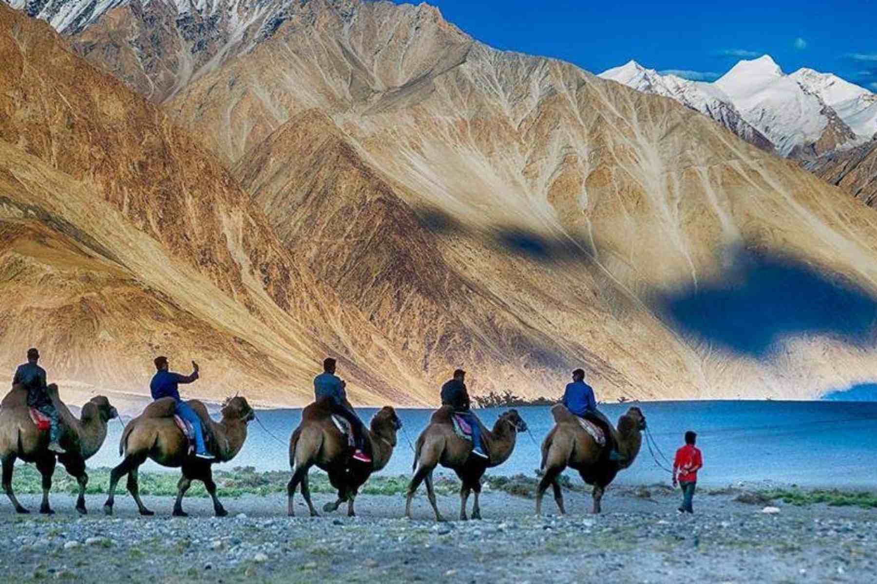
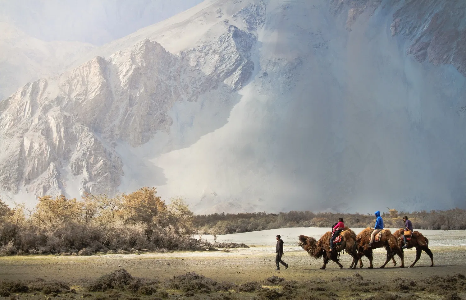
The Changthang is home to the Changpa nomads, pastoralists who move their herds of yaks, sheep, and especially pashmina goats between summer and winter pastures. These nomads have adapted to life at extreme altitudes, their entire culture shaped by the harsh environment. The pashmina wool from their goats is world-famous, used to make premium cashmere products.
Encountering Changpa nomads during your bike trip is one of the highlights. You'll see their black tents (rebos) pitched in pastures, their herds grazing on the sparse vegetation, and if you're lucky, you might interact with families who are always welcoming to travelers. The nomads' traditional way of life is increasingly threatened by modernization and climate change, making these encounters particularly precious.
Wildlife
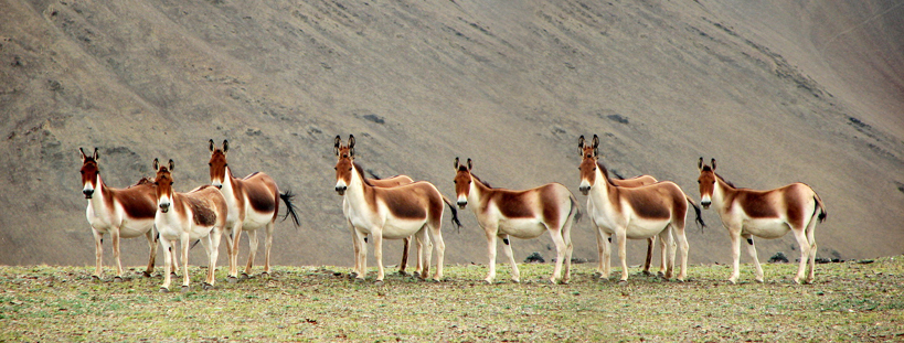
The Changthang plateau is a wildlife sanctuary home to species adapted to extreme altitude. The most famous is the Tibetan gazelle or chiru, known for its wool used in shahtoosh shawls. Kiang (Tibetan wild ass) are commonly seen grazing in herds. Black-necked cranes, elegant birds considered sacred in Buddhist culture, breed in the wetlands during summer. Snow leopards, though rarely seen, inhabit the more remote mountainous areas.
Route Options
Several route options exist for exploring Changthang, each offering different experiences and challenges. The choice depends on your time, experience level, and what you hope to see.
Route 1: Leh - Pangong - Hanle - Tso Moriri - Leh
This classic circuit takes you through the best of Changthang over 5-7 days. From Leh, you ride to Pangong Lake via Chang La Pass. After spending time at Pangong, you continue to Hanle, home to one of the world's highest astronomical observatories and a beautiful monastery. From Hanle, you ride to Tso Moriri Lake, then across the plains to Tso Kar before returning to Leh via Taglang La Pass.
This route offers incredible variety - the famous Pangong Lake, the remote Hanle Valley with its observatory and monastery, the spectacular Tso Moriri, and the surreal Tso Kar salt lake. It's challenging but accessible to riders with moderate experience and good fitness.
Route 2: Leh - Upshi - Tso Moriri - Tso Kar - Leh
This shorter route focuses on the southern Changthang and can be completed in 3-4 days. From Leh, you head east to Upshi, then south to Tso Moriri via Chumathang hot springs. After exploring Tso Moriri, you continue to Tso Kar before returning to Leh via the Morey Plains and Taglang La. This route skips Pangong and Hanle but still delivers a genuine Changthang experience.
Route 3: Complete Circuit
The complete circuit combines both routes above, essentially creating a loop that covers everything Changthang has to offer. This 7-9 day expedition takes you from Leh to Pangong, Hanle, Tso Moriri, Tso Kar, and back to Leh, covering approximately 700-800 kilometers. It's the ultimate Changthang experience but requires good planning, reliable equipment, and riding experience.
Complete Itinerary
Here's a detailed 5-day itinerary covering Leh, Pangong, Hanle, Tso Moriri, Tso Kar, and back to Leh. This can be extended with additional rest days or acclimatization days in Leh.
Day 1: Leh to Pangong Lake (via Chang La)
Distance: ~160 km | Riding Time: 6-7 hours
Depart Leh early morning, heading east across the Indus River Valley. The road climbs gradually through beautiful mountain scenery before the steep ascent to Chang La Pass (5,360m), one of the highest motorable passes in the world. The pass offers spectacular views and has a small army checkpoint. After the pass, descend to Tangste village where you can stop for lunch.
From Tangste, continue to Spangmik, the last village on Pangong's shore. The first view of Pangong Lake is unforgettable - the water shifts through shades of blue, green, and turquoise. Set up camp or check into a guesthouse in Spangmik or explore further along the shore. Afternoon is best spent by the lake, watching the colors change with the light.
Day 2: Pangong to Hanle (via Loma Crossing)
Distance: ~180 km | Riding Time: 7-8 hours
This is the longest and most challenging day of the trip. From Pangong, head north along the shore before turning east toward Chushul. The road passes through the village of Man, Merak, and Khaktse before reaching the Loma bend where you'll encounter the Indian and Chinese army camps.
The Loma crossing involves paperwork - you'll need Inner Line Permit stamps at the checkpost. After the crossing, the road continues through incredible remoteness. You'll see virtually no habitation for hours, only vast plains and distant mountains. The final approach to Hanle descends into a beautiful valley where the observatory dominates the skyline and the monastery sits on a hill above the village.
Day 3: Hanle to Tso Moriri (via Mahe Bridge)
Distance: ~120 km | Riding Time: 5-6 hours
Morning in Hanle is worth dedicating time to - visit the observatory if possible (check opening hours), explore the monastery, and walk through the village. The ride out of Hanle backtracks slightly before branching off toward Mahe Bridge.
The road to Mahe Bridge is spectacular, crossing high plains and descending into a valley where the Indus River flows. Mahe Bridge is a small settlement with a few houses. Continue from here toward Tso Moriri, ascending gradually to the lake. The first view of Tso Moriri is stunning - a vast expanse of deep blue surrounded by snow-capped peaks. Korzok village on the shore offers basic guesthouses and campsites.
Day 4: Tso Moriri to Tso Kar
Distance: ~80 km | Riding Time: 4-5 hours
This shorter day allows time to explore Tso Moriri in the morning. The lake is considered sacred, and the Korzok monastery dates back 400 years. After exploring, head north from the lake across rolling plains. The road is unpaved and can be rough in sections.
Tso Kar is a salt lake, quite different from Tso Moriri. The water is shallow and the lakebed creates surreal white patterns. The area around Tso Kar, especially the marshes of Startsapuk Tso, is excellent for birdwatching. Basic accommodation is available in the nearby village of Thukje.
Day 5: Tso Kar to Leh (via Taglang La)
Distance: ~150 km | Riding Time: 6-7 hours
The return journey crosses the Morey Plains, a 40-kilometer stretch of flat high-altitude desert where you can open up the throttle. The road then ascends to Taglang La Pass (5,328m), the second highest motorable pass. From the pass, it's a long descent through the Gya River valley to Upshi, then back along the Indus to Leh. Arrival in Leh by late afternoon allows time to celebrate the completion of an epic journey.
Road Conditions and Difficulty
The Changthang circuit presents varied riding conditions and specific challenges that riders should be prepared for.
Road Surface
Road conditions vary significantly. The Leh to Pangong road has been largely paved in recent years, though sections remain under construction. The road from Pangong to Hanle is mostly unpaved - rocky, dusty, and occasionally requiring water crossings. The route from Hanle to Tso Moriri via Mahe Bridge is also dirt road, rough in patches but generally rideable. The Tso Moriri to Leh route via Tso Kar and Taglang La has mixed surfaces - some paved sections, some good dirt roads, and some rough patches.
Altitude
The entire route is at high altitude. Leh is at 3,500m, and you'll be riding above 4,000m for most of the trip, crossing passes above 5,300m. Altitude sickness is a real risk. Acclimatize in Leh for at least 2-3 days before starting. Drink plenty of water, avoid alcohol, and descend immediately if symptoms worsen. The thin air also affects engine performance, reducing power by approximately 20-30%.
Fuel Availability
Fuel availability is a major consideration. There are no fuel stations on the route itself. The last fuel before Changthang is in Leh. Carry extra fuel in jerrycans - you'll need at least 10-15 liters extra depending on your bike's fuel efficiency. Total fuel capacity for the trip should be 20-25 liters. Some guesthouses in Korzok sell fuel at inflated prices, but availability isn't guaranteed.
Remote Riding
Once you leave Leh, you're in genuine wilderness. There are long stretches - 100+ kilometers - with no habitation, no mobile connectivity, and no traffic. If your bike breaks down, you'll need to be somewhat self-sufficient or wait for help. Carry basic tools, spare tubes, a puncture repair kit, and the knowledge to use them. Riding in a group is safer than solo riding.
Permits and Documentation
Several areas on the Changthang route require permits, which must be obtained in Leh.
Inner Line Permit
The Inner Line Permit (ILP) is required for most of the Changthang region. This can be obtained in Leh through registered travel agents or online through the official Ladakh administration website. The permit typically costs approximately INR 400-500 per person and is valid for multiple entries within a specified period (usually 7-14 days).
The permit must list all the locations you plan to visit: Pangong Lake, Spangmik, Hanle, Tso Moriri, and Tso Kar. Checkpoints at Loma, Chushul, and other locations will require you to present the permit and will stamp it.
Protected Area Permit
Some areas, particularly near Hanle Observatory, may require additional Protected Area Permit (PAP). This is usually arranged by observatory authorities if you're visiting, but independent travelers should check current requirements. Sometimes the ILP is sufficient, but regulations can change.
Documentation Required
To obtain permits, you'll need: Valid ID proof (Aadhaar card, passport, or voter ID), passport-sized photographs, and details of your itinerary. Foreign nationals have different permit requirements and should check current regulations as they differ from Indian citizens.
Places En Route
Pangong Tso
The famous endorheic lake spanning 134 kilometers. The water changes colors dramatically through the day. Best viewpoints are at Spangmik and further east toward Chushul.
Hanle
Remote village home to the Indian Astronomical Observatory and a 17th-century monastery. One of the most peaceful places in Ladakh with incredible night skies for stargazing.
Tso Moriri
Largest high-altitude lake in India. Sacred lake considered to be the remaining form of a goddess who tried to escape persecution by turning into water.
Tso Kar
Salt lake and wetland ecosystem. Important breeding ground for black-necked cranes and other bird species.
Korzok Village
One of the world's highest permanently inhabited villages at 4,595m. Home to an ancient monastery and basic guesthouses.
Chumathang Hot Springs
Natural hot springs perfect for a soak after days of riding. There are basic bathing facilities.
Mahe Bridge
Scenic bridge over the Indus River. Good spot for a break and photos.
Preparation and Tips
Acclimatization
Spend at least 2-3 full days in Leh before starting your trip. Use this time for short rides to nearby places to test your acclimatization. Don't underestimate altitude - it can be deadly.
Bike Preparation
Service your bike thoroughly before departure. Check brakes, suspension, tires (including spare), and electrical system. Ensure your bike is in excellent mechanical condition as breakdown assistance is far away.
Fuel and Spares
Carry 10-15 liters of extra fuel in secure jerrycans. Bring spare tubes, puncture repair kit, basic tools, clutch cable, brake cable, and any bike-specific parts you might need.
Clothing and Gear
Even in summer, temperatures can drop below freezing at night. Bring layered clothing including thermal wear, good riding jacket with rain liner, gloves, and balaclava. Sunscreen is essential at high altitude.
Emergency Equipment
Carry a first-aid kit with altitude sickness medication. A satellite phone is ideal but expensive. At minimum, have emergency contacts written down and know that help may be many hours away.
The Leh to Changthang bike trip is an adventure that will stay with you forever. The sense of accomplishment when you ride back into Leh, having navigated some of the most remote and beautiful terrain on Earth, is profound. The memories of vast plains, azure lakes, and the freedom of the open road in the high Himalayas will call you back to Ladakh again and again.
Location
Frequently Asked Questions
Q1.How far is Changthang from Leh?
Q2.What is the best time for Changthang bike trip?
Q3.How many days for Leh to Changthang circuit?
Q4.What is the route to Changthang Valley?
Q5.Are roads to Changthang in good condition?
Q6.Is Changthang bike trip difficult?
Q7.Do I need permits for Changthang?
Q8.Where can I stay in Changthang?
Recommended For You
Adventure Sports in Ladakh: High Altitude Thrills in Himalayan Paradise
Plan Ladakh adventure sports with expert tips on Khardung La biking, Zanskar rafting, Chadar trek, and high-altitude safety.
Leh Ladakh Family Trip: Itinerary, Acclimatization & Kid-Friendly Stops
Plan a safe family trip to Leh Ladakh with kids. Best time, itinerary, acclimatization tips & child-friendly activities included.
Flora and Fauna of Ladakh: Key Species, Habitats & Best Season
Discover the flora and fauna of Ladakh with key mammals, birds, alpine plants, protected areas, best wildlife zones, and responsible travel tips.
Never Miss an Adventure
Get the latest trekking guides, travel tips, and exclusive offers delivered straight to your inbox.