Most Dangerous Roads in India: Thrilling Routes
Neha Kapoor
February 15, 2026
Explore India's most dangerous roads. Zoji La, Killar-Kishtwar, Gata Loops, Rohtang & more with safety tips, challenges & adventure.
Most Dangerous Roads in India: Where Risk Is Real and How to Drive Safer
India has some of the most dramatic mountain and cliff roads in the world, but also some of the most unforgiving driving conditions. The keyword most dangerous roads in India attracts travelers who want both thrill and practical safety clarity. Many list articles describe roads but skip actionable risk management. This guide is different: each section explains hazard type, skill requirement, season windows, and readiness checks before you commit.
If you are combining these routes with high altitude itineraries, study acclimatization first using our Ladakh AMS safety guide. Route thrill is never more important than survival margin.
What Makes a Road Truly Dangerous
A road becomes dangerous when multiple risk layers overlap: narrow carriageway, blind curves, unstable slopes, poor weather visibility, loose gravel, inadequate guardrails, and long stretches without emergency support. In India, many high risk segments also include mixed traffic of trucks, tourist vehicles, bikes, and local transport sharing the same narrow lane.
Driver mindset is often the deciding factor. Speed confidence from city highways does not translate to mountain roads. Safer mountain driving means patience, low gear control, clear braking discipline, and willingness to stop early when visibility or road condition worsens.
High Risk Roads You Should Approach with Respect
1) Zoji La (Jammu and Kashmir to Ladakh)
Zoji La is known for extreme weather shifts, slushy sections, fog pockets, and tight passing points with heavy traffic pressure. It is one of the most psychologically demanding roads in North India. Road quality can vary rapidly within a short distance.
Risk pattern: low visibility, mud, truck congestion, sudden weather changes. Safer strategy: early start, updated road bulletin checks, and no aggressive overtaking.
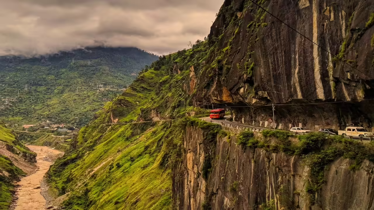
2) Killar Kishtwar Road (Himachal Jammu belt)
This route is often considered among the most intimidating due to cliff exposure, narrow cut sections, and minimal protective barriers. Mistakes here have very little recovery space. It is not for casual self drive tourists without mountain confidence.
Risk pattern: extreme drop edges and unpredictable surface wear. Safer strategy: experienced driver, dry weather preference, and daylight only movement.
3) Khardung La approach roads
While famous as an achievement road, the approach can involve broken patches, altitude fatigue, and traffic bottlenecks. The technical road challenge is often amplified by cold stress and low oxygen performance.
Couple or group itineraries should avoid combining this drive with sleep deficit and rushed schedules. Add a rest day before attempting high passes.
4) Rohtang and high monsoon connectors
Monsoon moisture, landslide threat, and slippery sections make several Himachal corridors unsafe during active rainfall windows. Traffic volume adds delay and fatigue. Choose post monsoon stable windows where possible.
5) Neral to Matheran bends
This section is lower altitude but still risky during rain due to sharp curves, narrow passages, and tourist traffic unpredictability. Do not underestimate it just because altitude is lower.
Best Seasons to Reduce Risk
In general, late spring and post monsoon windows offer better drivability on many mountain routes, though exact timing changes annually. Peak monsoon and deep winter amplify hazard probability through landslides, black ice, and closure risk. Always verify local authority updates before departure date.
For Spiti oriented routes, combine this guidance with our Spiti road trip planner and Spiti destination timing guide so itinerary design matches road reality.
Vehicle Selection for Dangerous Indian Roads
Choose condition over brand. A well maintained utility vehicle with healthy brakes, good tire tread, and reliable cooling performs better than a premium but unprepared car. Ground clearance matters on broken patches. Avoid overloaded roof setups that change balance on bends.
Carry essentials: puncture support, tow rope, portable inflator, flashlight, drinking water, thermal layer, power bank, offline maps, and emergency food. Fuel planning is critical on long remote stretches; refill at every confirmed station opportunity.
Driving Skills Required Before You Attempt
You should be comfortable with engine braking, first and second gear descent control, reversing on narrow bends, and yielding discipline at choke points. If these skills are weak, hire a local driver. Local experience is a safety asset, not a compromise.
Do not test your learning on a dangerous route with family onboard. Practice in moderate hills first, then scale challenge. Adventure without preparation is not bravery, it is avoidable risk.
On Road Safety Protocol
Start early: better visibility and lower traffic pressure. Keep distance: loose gravel and sudden braking events are common. Use horn before blind curves: especially on single lane mountain sections. Avoid night driving: many high risk roads have weak lighting and no immediate support.
If weather worsens quickly, stop at a safe settlement rather than pushing to target destination. Build itinerary buffers for such delays. The mountain decides pace, not your booking confirmation.
Emergency Response if Things Go Wrong
If brakes overheat, stop immediately at safe layby and cool systems naturally. If vehicle slips in mud, avoid panic acceleration; apply controlled traction methods. If landslide blocks route, do not attempt crossing unstable debris fields. Wait for official clearance.
In medical distress, prioritize descent to lower altitude when relevant and contact local authorities or nearest response unit. Keep at least one network from a provider known to work in your route region, plus offline emergency contact notes.
Who Should Avoid Self Drive on These Roads
First time mountain drivers, fatigued travelers on tight schedules, people with untreated motion or altitude sensitivity, and groups traveling with children without contingency plans should avoid self driving high risk roads. Hiring a trained local professional is often the smartest decision.
If your route includes vertical terrain activities, review safety standards in our Ladakh rock climbing guide to ensure your adventure stack remains realistic and safe.
Pre Departure Checklist for High Risk Routes
One day before departure, run a full vehicle check: brake response, tire pressure, spare wheel condition, coolant level, headlight and fog light function, and windshield clarity. Share route and expected check in times with two contacts at home. Download offline maps and mark fuel stations, medical points, and safe halt towns. Keep printed ID and permit copies because network outages are common in mountain corridors.
At briefing time, assign fixed travel roles in your group: primary driver, navigator, weather checker, and emergency contact person. This reduces confusion when conditions change. Carry dry snacks and enough water for delay scenarios because blockages can stretch for hours. A calm prepared team makes better decisions than a rushed excited group.
Finally, adopt the 70 percent rule: use only 70 percent of your driving confidence and vehicle capability on dangerous roads. Keep the rest as safety buffer for unexpected events like falling stones, sudden brake lights ahead, or blind corner encounters. This margin is what prevents incidents.
Final Verdict
The most dangerous roads in India are breathtaking, but they demand discipline, humility, and preparation. Choose the right season, keep your vehicle ready, drive below ego speed, and never ignore weather warnings. A safe arrival is the only successful road trip outcome. Document memories, not avoidable emergencies.
Whenever conditions feel uncertain, pause and reassess. Turning back is always a valid and intelligent safety decision on mountain roads.
For route extensions through high suspension bridges and remote valleys, check our Chicham Bridge travel note and Lahaul Spiti monastery circuit so you can design safer, better paced mountain journeys.
Location
Frequently Asked Questions
Q1.Which is the most dangerous road in India?
Q2.Are these roads open throughout the year?
Q3.What makes these roads dangerous?
Q4.Is it safe to drive on these roads?
Q5.What type of vehicle is best?
Q6.Do I need special driving skills?
Q7.What is the best time to travel?
Q8.Are there fuel stations on these routes?
Q9.What documents are required?
Q10.Is mobile network available?
Recommended For You
Monasteries in Lahaul Spiti: Buddhist Heritage
Explore ancient monasteries in Lahaul Spiti. Complete guide to Tabo, Ki, Dhankar, Kye & other Buddhist monasteries with travel tips.
Acute Mountain Sickness in Ladakh: Prevention
Complete guide to Acute Mountain Sickness in Ladakh. Learn symptoms, prevention, medicines, acclimatization tips & safety measures for high-altitude travel.
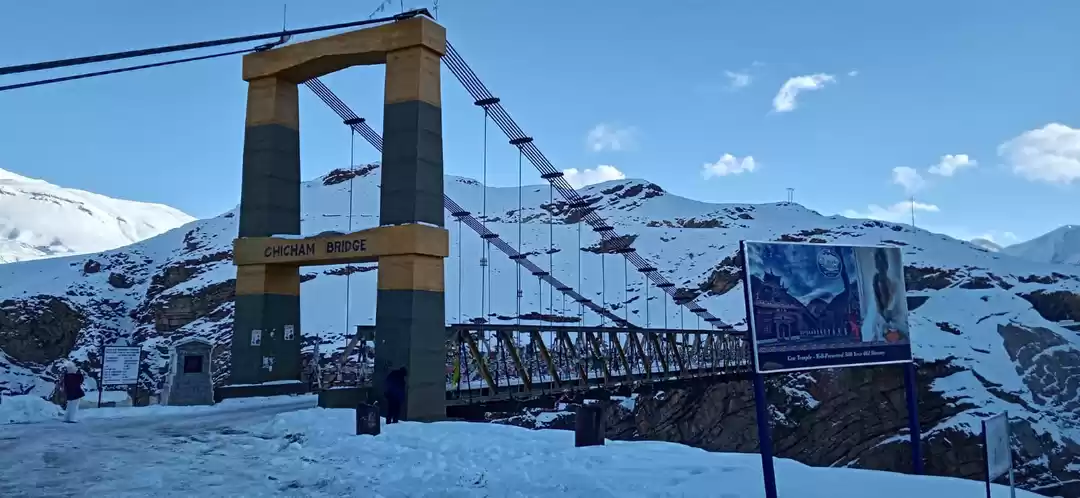
Chicham Bridge Spiti: Height, Location & Best Photo Points
Plan Chicham Bridge Spiti with height facts, Kibber route details, safety tips, best season, and nearby attractions for a smooth high-altitude visit.
Never Miss an Adventure
Get the latest trekking guides, travel tips, and exclusive offers delivered straight to your inbox.