Chicham Bridge Spiti: Height, Location & Best Photo Points
Rahul Garg
February 19, 2026
Plan Chicham Bridge Spiti with height facts, Kibber route details, safety tips, best season, and nearby attractions for a smooth high-altitude visit.
Introduction
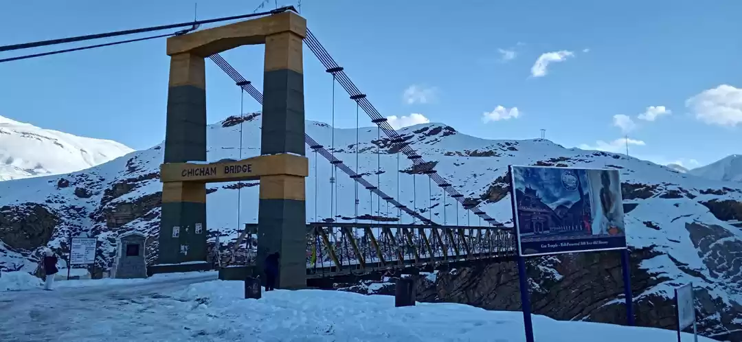
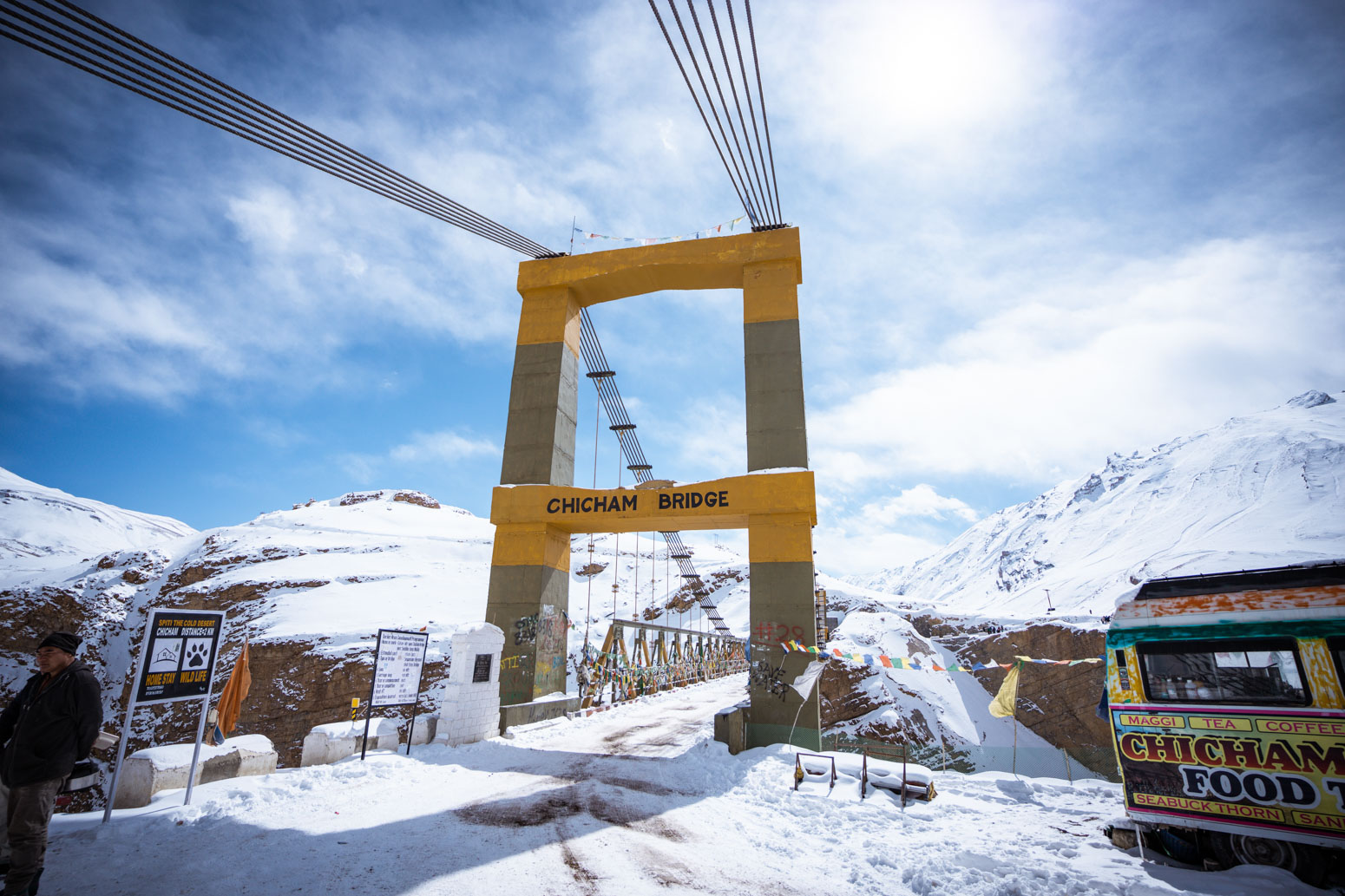
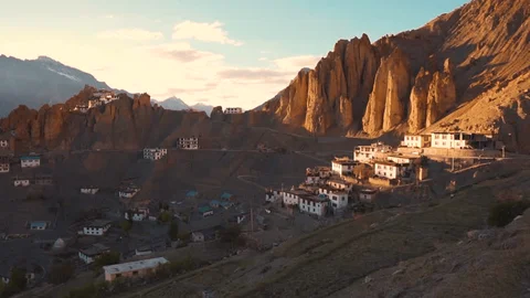
Chicham Bridge in Spiti Valley is one of the most talked-about engineering landmarks in the high Himalaya. Set between Kibber and Chicham villages above a dramatic gorge, the bridge changed local connectivity and became a must-stop for travelers exploring the Kaza circuit. What makes it special is not only the altitude but also the feeling of crossing a narrow, wind-exposed span with deep valley views on both sides.
If your search intent is practical planning, this guide gives you what you need: location clarity, commonly reported height and construction details, route planning from Kaza, road and weather cautions, photography tips, and nearby places to combine in one day. For a wider itinerary, pair this stop with Kaza, Key Monastery, and a longer Spiti Valley road trip.
Where Is Chicham Bridge Located?
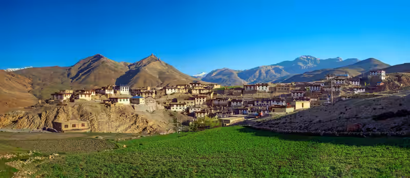
Chicham Bridge is in Himachal Pradesh’s Spiti region, on the route connecting Kibber village to Chicham village near Kaza. Most travelers approach from Kaza, making it an easy half-day or full-day loop with monasteries and high villages nearby. The landscape is classic Spiti: barren slopes, deep-cut valleys, thin air, and rapidly changing mountain weather.
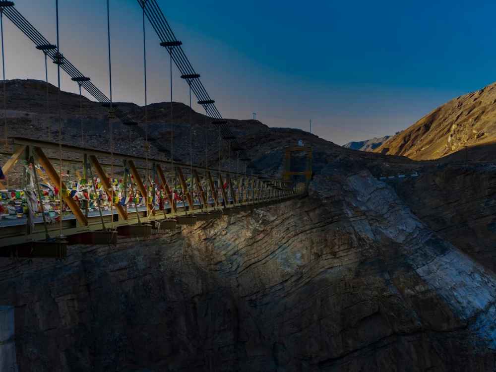
The bridge spans a gorge locally associated with the Samba Lamba nullah region, where crossing once depended on a ropeway arrangement used by villagers. With the bridge in place, travel is more reliable, especially for local movement and essential access during the open road season.
| Location Snapshot | Details |
|---|---|
| Region | Spiti Valley, Himachal Pradesh |
| Nearest base town | Kaza |
| Route connection | Kibber to Chicham |
| Terrain type | High-altitude cold desert |
Chicham Bridge Height, Length, and Key Facts
Public tourism and road references commonly describe Chicham as one of the highest suspension bridges in Asia by elevation context. Reported figures usually place it at around 13,500 feet above sea level (about 4,000+ meters), with a span close to 120 meters. Depth figures for the gorge vary across sources, so treat exact depth claims as approximate unless you are using official engineering documentation.
For travelers, the exact number matters less than the on-ground reality: thin air, strong crosswinds on some days, and an exposed crossing with steep drop views. It is a viewpoint as much as a transport link.
| Bridge Fact | Commonly Reported Value | Visitor Relevance |
|---|---|---|
| Elevation zone | Approx. 13,500+ ft | Expect altitude effects |
| Bridge span | About 120 meters | Short but memorable crossing |
| Type | Suspension bridge | Visible sway sensation in windy weather |
| Open mountain exposure | High | Keep weather buffer in plan |
History and Construction Background
Before the bridge, villagers in this belt used older and riskier methods to cross the gorge. The construction of Chicham Bridge significantly improved inter-village mobility, public service access, and travel safety compared to earlier arrangements. Multiple travel and regional reports place inauguration in 2017 after multi-year work in difficult high-altitude conditions.
Building at this elevation is not routine civil work. Logistics are constrained by a short construction season, freezing temperatures, and limited heavy-equipment windows. These conditions are why Chicham Bridge is widely seen as both a practical infrastructure success and a tourism landmark.
Why the Bridge Matters Beyond Tourism
- Local connectivity: Faster, safer movement between remote settlements.
- Emergency support: Better route continuity for medical and supply access.
- Economic value: Easier transport and stronger visitor footfall in nearby villages.
- Regional identity: A symbol of modern engineering in a fragile mountain landscape.
Best Time to Visit Chicham Bridge
The most practical season is generally May to October, when Spiti road access is more reliable and weather is comparatively stable. Shoulder months can still be cold, especially mornings and evenings, but visibility is often good for photography and valley views.
Winter travel is possible only with strong preparation and real-time road checks. Snow, black ice, and wind chill can make quick sightseeing plans unrealistic. Monsoon affects approach roads from some directions, and landslide-prone stretches can delay movement depending on your route into Spiti.
| Season | Condition Overview | Planning Advice |
|---|---|---|
| May to June | Clear skies, cold mornings | Best for first-time visitors |
| July to September | Variable road conditions on approach routes | Track road and weather updates daily |
| October | Crisp weather, fewer crowds | Great for photographers |
| November to April | Harsh cold, potential closures | Only for prepared high-altitude travelers |
How to Reach Chicham Bridge from Kaza
From Kaza, Chicham Bridge is usually done as a drive through Kibber side roads. Distances are modest, but mountain driving time depends on road surface, traffic bottlenecks, and weather. Most travelers hire local taxis, ride bikes, or self-drive SUVs with adequate ground clearance.
Route Pattern
- Kaza to Kibber belt: gradual climb with scenic barren mountain views.
- Kibber to Chicham stretch: narrower high-altitude road segments.
- Bridge stop: short parking halt, crossing, and photo time.
| Mode | Best For | Limitations |
|---|---|---|
| Local taxi from Kaza | Families and relaxed itineraries | Higher cost than shared options |
| Self-drive SUV | Flexible multi-stop day plan | Needs mountain driving confidence |
| Bike ride | Adventure-focused travelers | Wind, dust, and fatigue at altitude |
Keep extra buffer if you are continuing to Kibber attractions or planning sunset shots near high passes.
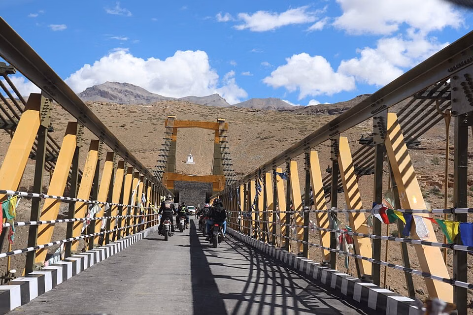
The Crossing Experience: What It Feels Like
Crossing Chicham Bridge is short in time but intense in feel, especially if this is your first high-altitude suspension bridge. Wind can be strong, and the gorge view below creates a real sense of exposure. Vehicles cross steadily, but drivers should keep lane discipline and avoid sudden halts in active movement windows.
If you walk sections for photos, stay alert to traffic and avoid standing at blind approach points. The best experience is a calm pass with planned stop points, not risky edge behavior.
On-Site Safety Rules You Should Follow
- Do not lean over railings for extreme-angle photos.
- Avoid crowding in narrow vehicle movement stretches.
- Keep children close and supervised at all times.
- Skip risky drone flying unless explicitly permitted locally.
- Pause only where safe pull-over room exists.
Photography Tips for Chicham Bridge
Chicham is one of the most photogenic structures in Spiti because geometry and terrain work together: clean bridge lines, steep gorge depth, and layered brown-grey mountains. The best frames usually come from approach bends and side viewpoints rather than only mid-span photos.

Golden-hour windows create warmer tones on otherwise stark terrain. Midday gives sharper visibility but flatter contrast. In windy weather, stabilize your phone or camera and keep lens cloth ready due to dust.
| Photo Goal | Best Timing | Tip |
|---|---|---|
| Wide bridge + gorge frame | Morning | Use approach-point elevation for scale |
| Bridge silhouette against valley | Late afternoon | Expose for highlights to protect sky detail |
| Vehicle crossing motion shot | Daylight with moderate traffic | Shoot from safe shoulder only |
| Landscape set | Any clear day | Include mountain layers for depth |
Nearby Places to Combine in One Circuit
Chicham Bridge is best treated as part of a circuit, not a standalone destination. The surrounding belt includes villages, monasteries, and viewpoints that can be covered in one structured day from Kaza.
| Nearby Stop | Why Add It | Typical Fit |
|---|---|---|
| Key Monastery | Spiritual and architectural highlight of Spiti | Half-day cultural + scenic route |
| Kaza town | Food, fuel, and logistics base | Start/end anchor point |
| Gette Village | Remote high-village atmosphere | Extended day option |
| Dhankar Monastery | Dramatic cliffside heritage stop | Separate day or long circuit add-on |
Sample Half-Day Plan from Kaza
| Time Block | Suggested Plan |
|---|---|
| 07:30 to 08:30 | Breakfast and weather/road status check in Kaza |
| 08:30 to 10:00 | Drive toward Kibber-Chicham belt |
| 10:00 to 11:00 | Bridge stop, crossing, photography, short walk |
| 11:00 to 13:00 | Add nearby village/monastery stop and return |
Altitude, Health, and Road Precautions
- Acclimatize in Kaza before aggressive same-day rushing.
- Hydrate well; dry air increases fatigue quickly.
- Avoid sprinting for photos at high altitude.
- Carry layered clothing even in sunny weather.
- Keep fuel and cash buffer for remote segments.
- Respect local traffic and do not block road edges for reels.
High-altitude trips are smoother when pace is conservative and schedule buffers are realistic.
Practical Packing Checklist for Chicham Stop
Even for a short bridge visit, packing correctly improves safety and comfort in Spiti. Weather can shift fast from sunny to windy and cold, so a light layer system is better than one heavy jacket. Keep hydration easy to access because dry high-altitude air causes fatigue quickly, especially if you combine Chicham with other villages in one day.
| Item | Why You Need It |
|---|---|
| Windproof layer | Bridge area can feel much colder than vehicle interior |
| Water and electrolytes | Helps with dry-air dehydration at altitude |
| Sunglasses and sunscreen | Strong UV exposure in high barren terrain |
| Basic medicines | Useful for headache, nausea, and minor travel discomfort |
| Offline map backup | Network instability in remote segments |
Keep your stop intentional: park safely, cross calmly, take photos from secure points, and move ahead without unnecessary road blocking. Responsible behavior keeps this iconic Spiti bridge enjoyable for everyone.
Common Mistakes to Avoid
- Treating Chicham as a quick stop with no weather backup.
- Ignoring wind chill and stepping out in light clothing.
- Attempting unsafe mid-road photo setups.
- Skipping acclimatization before high-point hopping.
- Assuming identical road conditions across all Spiti routes.
Conclusion
Chicham Bridge Spiti is more than a check-in point. It is a rare mix of infrastructure achievement, mountain drama, and practical route significance for remote villages. The crossing is brief, but the setting leaves a strong impression, especially when combined with surrounding Spiti landmarks.
Plan around weather, drive with caution, respect high-altitude limits, and include nearby village or monastery stops for a richer day. With that approach, Chicham Bridge becomes one of the most memorable segments of a Spiti journey.
Location
Frequently Asked Questions
Q1.Where is Chicham Bridge located?
Q2.What is the height of Chicham Bridge?
Q3.How far is Chicham Bridge from Kaza?
Q4.What is the best time to visit Chicham Bridge?
Q5.When was Chicham Bridge opened?
Q6.Is Chicham Bridge safe for vehicles?
Q7.Can tourists walk on Chicham Bridge?
Q8.Are there restrictions for drone photography?
Recommended For You
Dhankar Monastery Spiti: Monastery Visit, Trek Route & Stay Options
Discover Dhankar Monastery in Spiti Valley, a 900-year-old cliff-top wonder at 3,894 meters. Complete guide with Dhankar Lake trek, history, how to reach, timings & travel tips.

Gette Village Spiti: Kaza's Hidden Gem
Visit Gette Village in Spiti Valley. Complete guide with homestays, trek from Kaza, altitude, best time & how to reach this hidden gem.
Places to Visit in Kibber: Spiti Village Highlights & Trails
Explore places to visit in Kibber with village highlights, nearby landmarks, and practical high-altitude travel planning tips.
Never Miss an Adventure
Get the latest trekking guides, travel tips, and exclusive offers delivered straight to your inbox.