Chandra Taal Spiti: Mythology, Camping Rules & Trek Route
Ananya Sharma
January 11, 2026
Discover Chandra Taal Lake in Spiti Valley. Uncover local myths, trekking guide, camping tips, and best time to visit this sacred Moon Lake.
Chandra Taal Spiti Valley: Myths, Mountains, and a Practical Trek Guide
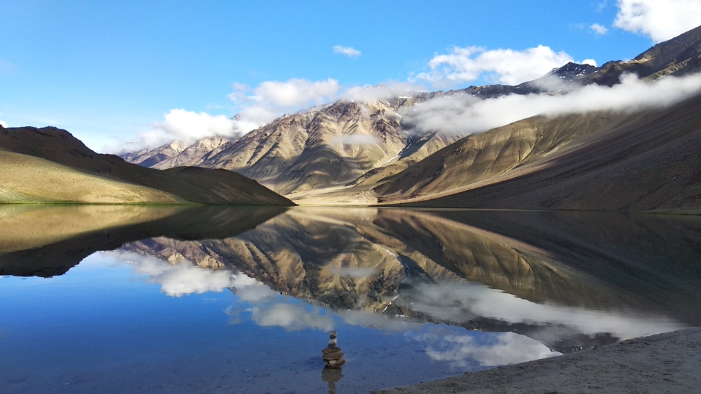
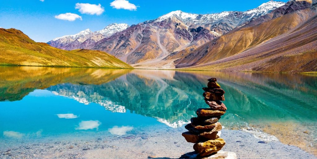
Chandra Taal in Spiti Valley is one of those places where landscape and folklore feel equally powerful. At first glance, it is a high-altitude lake with changing shades of blue. But the longer you stay, the more you hear stories about gods, celestial pathways, and unexplained lights over the water. Most travelers arrive through the same circuit that includes Dhankar Village, then discover that Chandra Taal is not just a scenic halt but a place shaped by weather, altitude, and local belief systems. If you are curious about mountain mysteries, you may also like our features on mysterious flights and planes stopping mid-air, where perception and science often overlap. This guide explains both the legends and the logistics so you can plan a safe, meaningful visit.

Why Chandra Taal Is Called the Moon Lake
The name Chandra Taal translates to "Moon Lake," and the shape of the shoreline partly explains it. From elevated points, the curve of the lake resembles a crescent. In local narratives, however, the name goes beyond geometry. Elders in nearby settlements connect the lake with episodes from epic traditions, especially stories of divine ascent and sacred crossing routes. Travelers often hear a version where celestial beings paused here on their way through the high passes. Whether you treat these stories as history or heritage, they influence how locals interact with the site. You will notice quieter behavior, limited noise, and a general sense that this is not just a picnic spot but a spiritually respected landscape.
Popular Myths You Will Hear on the Route
Myth 1: The lake changes color because of supernatural forces
The color shifts are real, but the reason is scientific. Angle of sunlight, depth, suspended particles, and cloud movement create dramatic transitions from turquoise to steel blue. Myth and science both survive because the visual change is so fast that it feels unreal.
Myth 2: No one should camp near the water after dark
There are restrictions near the immediate lake edge, but these exist mainly for ecological protection and safety. The ground can be fragile, weather can turn quickly, and nighttime temperatures drop sharply. Authorized campsites are set back from the core lake zone.
Myth 3: Strange sounds at night are spirits
Strong wind corridors, tent movement, loose equipment, and distant streams can produce eerie sounds. At high altitude, even normal noise feels amplified. It is unsettling for first-time campers, which is why myth narratives remain popular.
Geography and Altitude: What Makes This Lake Unique
Chandra Taal sits above 4,000 meters in the Lahaul-Spiti region and is fed seasonally by snowmelt. This altitude matters more than most first-timers expect. Oxygen levels are lower, physical activity feels harder, and dehydration happens quickly in dry mountain air. The lake appears calm, but the surrounding system is dynamic, with sudden wind bursts and rapidly moving cloud banks. The road approach is rough in sections, usually with loose stones and occasional water crossings depending on the month. This is why acclimatization is not optional. Travelers who rush directly from low altitude often report headaches, nausea, or disturbed sleep. Plan a gradual ascent and keep buffer days if possible.
Best Time to Visit Chandra Taal
The practical travel window is short. Late June to early October is generally considered accessible, though exact opening and closing depend on snowfall and road condition. July and August offer greener slopes and fuller water, but occasional rain can affect road quality. September is often preferred for cleaner skies and stronger mountain visibility. By October, nights turn very cold and services begin to reduce. Winter access is usually closed for regular tourism due to heavy snow and pass shutdowns.
| Month | Road Condition | Crowd Level | What to Expect |
|---|---|---|---|
| Late June | Partially open, improving | Low to moderate | Cold nights, early season setup |
| July-August | Mostly open, some rough patches | Moderate to high | Active camps, variable weather |
| September | Generally stable | Moderate | Clear views, crisp mornings |
| Early October | Uncertain, weather dependent | Low | Very cold nights, fewer facilities |
How to Reach Chandra Taal from Manali and Kaza
Most routes are planned from Manali side or Kaza side. From Manali, the route usually crosses high passes and includes long rough segments, so start early and avoid driving after sunset. From Kaza, travelers often combine monasteries and villages before moving toward the lake zone. A common strategy is to break the trip with a halt at moderate altitude and only then continue. If you are building a longer itinerary, combine this with Dhankar Village and neighboring circuits rather than rushing in and out the same day. Fuel and repair support are limited, so top up in major hubs and carry essentials such as medicines, warm layers, and backup food.
The Chandra Taal Trek and Walking Section
Depending on where your vehicle halts, you will typically complete a short but meaningful walk toward the lake viewpoint. At this altitude, even a modest gradient can feel demanding. Pace matters more than speed. Keep your breath steady, pause frequently, and avoid sudden bursts. The trail is usually manageable for beginners with basic fitness, but the challenge is oxygen, not terrain complexity. Trekking shoes with grip are recommended because loose dirt and gravel can shift underfoot. During peak season, you may see multiple groups at the same time, so start early for quieter trails and better photography light.
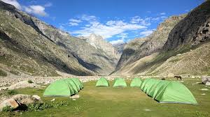
Camping Rules, Safety, and Responsible Travel
Camping near Chandra Taal is one of the main reasons travelers stay overnight, but it requires discipline. Use designated camps, follow local instructions, and avoid setting private tents too close to the waterline. High-altitude weather can shift fast, so keep dry layers, gloves, and a windproof outer shell ready. Hydrate through the day even if you do not feel thirsty. Avoid alcohol on arrival night because it can worsen altitude symptoms. Waste management is critical in fragile ecosystems; carry back plastics and avoid soap use near streams. Respecting these basics protects both your health and the landscape.
- Arrive with acclimatization, not in a hurry from low altitude.
- Choose official camps with blankets, meals, and emergency contact support.
- Carry a reusable bottle and personal medicines.
- Keep noise low, especially after sunset.
- Leave no litter around viewpoints or camp trails.
Photography Tips at Chandra Taal
Morning and late afternoon usually deliver the best contrast and texture in the mountain backdrop. Midday light can flatten depth, though reflections still look strong on calm days. For wide lake frames, step back and include foreground stones or trail lines for scale. If you want dramatic storytelling shots, capture moving clouds over the water and trekkers on the rim path. Keep batteries warm because cold drains charge faster. A simple microfiber cloth helps when dust and spray settle on lenses. Avoid standing on delicate wet edges for social-media angles; many unstable spots look safe but are not.
Myth, Media, and Reality
Chandra Taal often appears online as either a supernatural hotspot or a fully commercialized destination. Both views are incomplete. It is a sacred and ecological site that receives seasonal tourism pressure. The right approach is to hold two truths together: local belief deserves respect, and practical planning is essential. The same balance appears in other popular mystery topics such as the Bermuda Triangle and Jatinga bird mystery, where storytelling grows quickly but context explains most patterns. For Chandra Taal, context means altitude science, weather behavior, road realities, and local culture.
Sample One-Day Visit Plan (From Nearby Base)
If you are already in the region and acclimatized, a one-day plan works with careful timing: early departure, lake walk by morning, relaxed viewing, lunch break, then return before evening weather builds. Do not push into late-night driving on rough mountain roads. Keep at least one backup day in your wider itinerary in case road conditions delay movement. This flexibility prevents risky decisions and improves the overall experience.
Final Takeaway
Chandra Taal Spiti Valley is memorable because it combines raw Himalayan terrain with deeply rooted oral traditions. You do not have to choose between myth and practicality; good travel uses both. Listen to local stories, but plan with altitude awareness, weather buffers, and responsible habits. If you travel slowly and respectfully, the Moon Lake gives you far more than a postcard view: it gives you a fuller understanding of how culture and landscape shape each other in high mountain regions.
Location
Frequently Asked Questions
Q1.Where is Chandra Taal Lake located?
Chandra Taal Lake is located in the Spiti Valley of Himachal Pradesh.
Coordinates: 32°28'N 78°26'E
Altitude: 4,270 meters (14,040 feet) above sea level
Location: Near Chicham Bridge in Spiti Valley
From Kaza: Approximately 8 km
From Manali: Approximately 130 km via Kunzum Pass
The lake sits in a high-altitude desert surrounded by snow-capped mountains and barren, beautiful landscapes.
Q2.What is the best time to visit Chandra Taal?
The best time to visit Chandra Taal is during summer months.
Recommended Period: June to mid-September
Lake Condition: Full, crystal-clear waters at maximum size
Access: Kunzum Pass open, roads accessible
Temperature: Pleasant days (10-20°C), cold nights (0-5°C)
Early Summer: June to July - fewer crowds, meadows blooming
Late Summer: August to September - lake at maximum beauty, but peak tourist season
Avoid winter (November to April) - Kunzum Pass closed and lake inaccessible.
Q3.How far is Chandra Taal from Manali?
Chandra Taal is approximately 130 km from Manali.
Travel Time: 6-8 hours (depending on road conditions)
Route: Via Kunzum Pass (at 4,590 meters)
Key Points:
- Manali to Grapoo: 50 km via Rohtang Pass
- Grapoo to Kunzum Pass: 12 km
- Kunzum Pass to Chandra Taal: 3 km
Important: Kunzum Pass only open from June to October/November. Road conditions can be rough - SUV or 4x4 recommended.
Q4.Why is Chandra Taal called Moon Lake?
Chandra Taal is called "Moon Lake" due to its crescent shape and divine mythology.
Literal Meaning:
- "Chandra" means "Moon" in Hindi
- "Taal" means "Lake"
Shape: The lake has a distinctive crescent shape that resembles the moon
Mythological Origin: According to local legend, the moon god (Chandra) created the lake with a touch of his finger
Reflective Qualities: The lake's mirror-like surface reflects the surrounding mountains and sky like the moon reflects sunlight
The combination of physical appearance and divine legends earned it the poetic name "Moon Lake."
Q5.What are the local legends about Chandra Taal?
Chandra Taal has several fascinating local legends and myths:
Divine Origins: The moon god (Chandra) created the lake with his finger, making it sacred
Mermaid Guardian: A beautiful mermaid is said to reside in the lake's depths, appearing to grant wishes or predict weather
Invisible Protectors: Invisible spirits guard the sacred lake, punishing those who pollute or disrespect it
Weather Prediction: Color changes, mysterious ripples, and fog patterns are believed to forecast weather
Samundra Tapu: The nearby peak serves as a cosmic antenna between the lake and the heavens
Blessings and Curses: Pure-hearted visitors may receive blessings, while disrespectful behavior brings bad luck
Q6.Is Chandra Taal considered sacred?
Yes, Chandra Taal is considered sacred by local Buddhist communities in Spiti Valley.
Sacred Status:
- Believed to have divine origins (created by moon god)
- Home to protective spirits and invisible guardians
- Used for centuries for weather prediction and spiritual contemplation
- Connected to Samundra Tapu peak for cosmic communication
Local Beliefs:
- The lake should be respected and not polluted
- Disrespectful behavior brings bad luck
- Pure intentions may be blessed
- Visitors should show reverence for the lake and surrounding area
These beliefs have been part of Spiti culture for generations and are deeply respected by both locals and visitors.
Q7.Is trek to Chandra Taal difficult?
The difficulty of trekking to Chandra Taal depends on your approach route.
From Kaza: Easy to Moderate
- Mostly vehicle-accessible via road
- Only 3 km from Kunzum Pass turnoff
- 30 minutes to 1 hour walking
- Suitable for most fitness levels
From Manali: Moderate to Difficult
- Rough mountain road conditions
- Requires SUV or 4x4
- 6-8 hours driving time
- Not suitable for sedans
From Remote Villages (e.g., Kibber): Difficult
- 12 km trek over challenging terrain
- 5-7 hours required
- Requires high-altitude trekking experience
- Navigation skills needed
Recommendations: Most visitors access via road from Kaza or Manali rather than trekking from remote villages.
Q8.Can we camp at Chandra Taal Lake?
Yes, you can camp at Chandra Taal Lake, and it's one of the most memorable Himalayan camping experiences.
Camping Locations:
- Multiple flat areas near the lakeshore
- Higher ground options with better views
- Relatively secluded spots available
Best Time: June to September (during accessible months)
Essential Guidelines:
- Leave No Trace (pack out all waste)
- No fires allowed (use camping stoves only)
- Camp away from water's edge (50+ meters)
- Use biodegradable soap 50+ meters from lake
Camping Gear Needed:
- 4-season tent (rated for -10°C to -15°C)
- Insulated sleeping bag and pad
- Camping stove with adequate fuel
- Water treatment (filter or purification tablets)
- Headlamp and comprehensive first aid kit
Important: The area is sacred - camp respectfully and minimize environmental impact.
Q9.What should I carry for Chandra Taal trek?
Essential items for Chandra Taal trek and camping:
Clothing:
- Warm layers (thermal, fleece, down jacket)
- Waterproof windbreaker
- Comfortable trekking pants
- Warm hat and gloves
- Sturdy hiking boots
Camping Gear:
- 4-season tent
- Sleeping bag rated for -10°C to -15°C
- Insulated sleeping pad (R-value 4+)
- Camping stove and fuel
Essentials:
- Water treatment (filter or tablets)
- Headlamp or flashlight
- Sunscreen and sunglasses
- Lip balm with SPF
Safety:
- First aid kit (including AMS medication)
- Emergency whistle and emergency blanket
- Multi-tool or knife
- Power bank and charger
Important: Weather can change rapidly in high altitude - prepare for cold, wind, and sudden storms.
Q10.Is Chandra Taal accessible in winter?
No, Chandra Taal is not accessible in winter months.
Winter Period: November to April
Access Barriers:
- Kunzum Pass (the only route from Manali) is closed due to snow
- Road conditions make driving impossible
- Temperatures are extremely cold (-15 to -30°C)
- Lake is frozen or dried
Seasonal Window:
- Accessible: June to October/November (weather-dependent)
- Best conditions: July to September
Recommendation: Do not attempt to visit Chandra Taal during winter. The pass closures and extreme weather make it dangerous and impossible to reach.
Recommended For You
Camping in Spiti Valley: Complete Guide 2026
Complete guide to camping in Spiti Valley: Chandratal Lake, Kaza, Langza, best campsites, costs, safety tips & what to carry for an unforgettable Himalayan experience.
Dhankar Village Spiti: Monastery, Lake & Stay Options
Explore Dhankar Village in Spiti Valley. Visit ancient monastery, Dhankar Lake, homestays, trekking & travel guide.
Best Time to Visit Spiti Valley: Road Status, Season & Itinerary Fit
Discover the best time to visit Spiti Valley with season-wise weather, road status windows, and month-by-month planning tips for road trips, treks, and Chandratal.
Never Miss an Adventure
Get the latest trekking guides, travel tips, and exclusive offers delivered straight to your inbox.