Suraj Tal Lake Ladakh: Route, Best Time & High-Altitude Tips
Rahul Garg
January 7, 2026
Discover Suraj Tal with route planning, altitude context, best season, weather realities, nearby stops, and practical safety tips for high mountain travel.
Introduction: Suraj Tal, the High-Altitude Lake on the Manali-Leh Axis
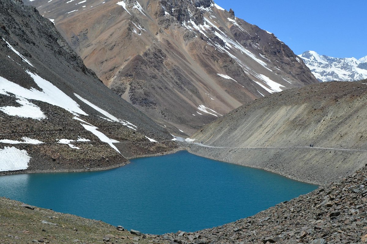
Suraj Tal is one of the most dramatic high-altitude lakes on the Manali-Leh highway corridor, located near Baralacha La in the Lahaul-Spiti region. Many travelers searching for Suraj Tal Lake Ladakh use the term Ladakh for the broader overland route context, but geographically the lake lies in Himachal Pradesh and serves as a key visual and hydrological landmark on the approach toward Ladakh sectors. Its raw setting, cold alpine water, and stark mountain backdrop make it one of the most memorable stops on this highway.
Unlike urban-access lakes, Suraj Tal is a route-based destination. You do not visit it casually; you reach it as part of a high mountain travel plan where road conditions, season windows, and altitude management decide how smooth your experience will be. That is why this guide focuses on practical crossing strategy, weather behavior, and route planning instead of only sightseeing highlights.
For a broader route framework, combine this with Spiti Valley road trip and how to reach Spiti Valley planning.
1. Location and Altitude of Suraj Tal
Suraj Tal is situated near Baralacha La on the Manali-Leh road corridor at high elevation, commonly referenced around 4,880 meters (approx 16,000 feet) above sea level depending source conventions. The lake sits in a harsh trans-Himalayan zone where vegetation is sparse, temperatures drop quickly, and weather changes can be abrupt even during travel season.
Why This Location Matters
- It is one of the highest accessible lakes on this highway route.
- The lake is close to major pass-based transit movement.
- Altitude and wind exposure require careful stop-time management.
- It is often visited with nearby Baralacha and Deepak Tal segments.
This is not a long-stay lake destination for most travelers. It works best as a controlled high-altitude halt during a longer mountain journey.
2. Geography and Significance
Suraj Tal is often described as a glacially influenced high-altitude lake and is associated with the headwater region feeding the Bhaga river system. In regional travel narratives, it is also known as the lake of the Sun God, adding devotional-cultural significance to its landscape value.
From a travel perspective, the importance of Suraj Tal lies in three dimensions: extreme altitude, route symbolism on the Manali-Leh axis, and strong visual identity. The lake's blue-gray water tone and surrounding barren slopes create a stark contrast from forested Himalayan valleys at lower elevations.
| Feature | Why It Matters | Traveler Impact |
|---|---|---|
| High altitude | Thin air and low oxygen | Short, controlled halts recommended |
| Near Baralacha section | Pass-linked road exposure | Weather and road timing become critical |
| Glacial environment | Cold water and wind-prone terrain | Carry layers even in summer |
| Route landmark value | Iconic stop on overland journeys | Best seen as part of day transit block |
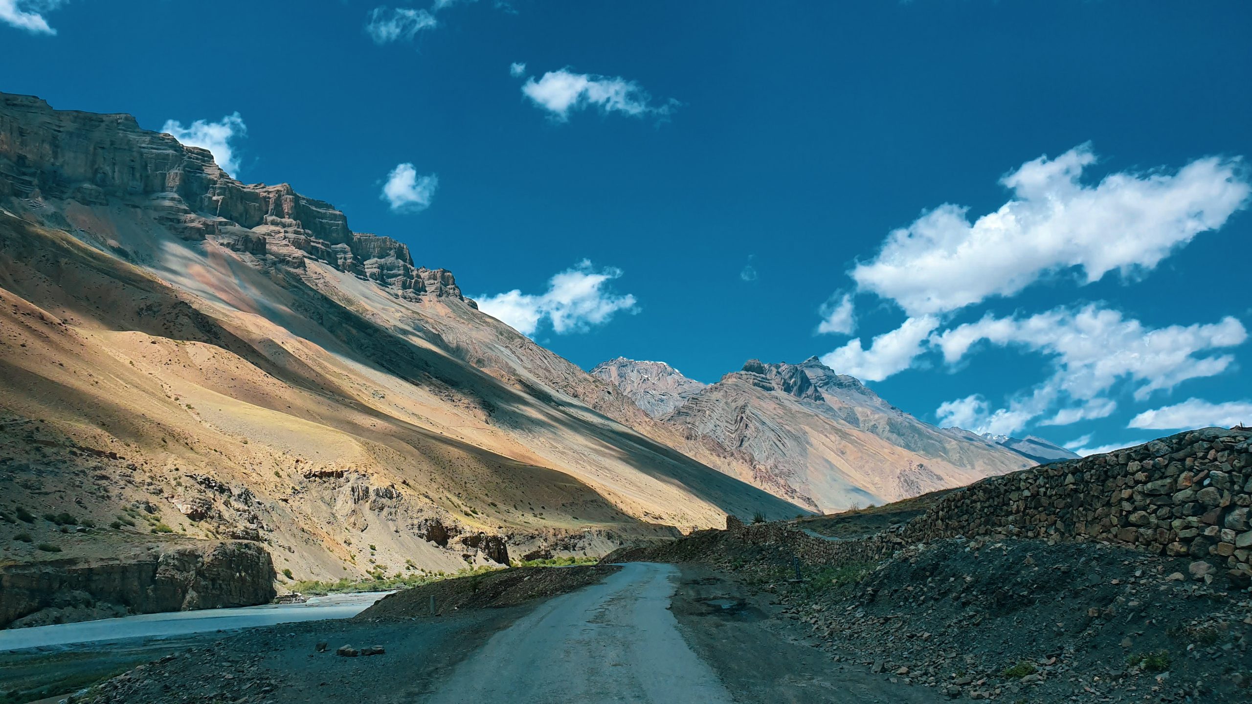
3. How to Reach Suraj Tal from Manali and Leh Sides
From Manali Side
The common route follows Manali-highway sectors through high mountain transitions before reaching Suraj Tal near Baralacha belt. Many travelers split this over two days due distance, road quality, and acclimatization needs. Trying to do a rushed same-day long-haul can reduce safety margins.
From Leh Side
Travelers coming from Leh generally pass through long high-altitude road sectors toward Sarchu-Baralacha direction before reaching Suraj Tal zone. This side is also highly weather dependent and should be planned with fuel and daylight buffers.
Transport Modes
- Self-drive SUV with mountain-road readiness.
- Rented motorcycle (experienced riders only for rough weather windows).
- Local hired taxi on intercity route plans.
For route details beyond Suraj Tal, use Manali to Kaza and Leh bike-route planning references for sequencing decisions.
4. Best Time to Visit Suraj Tal
The practical window for Suraj Tal access is tied to highway opening season and pass status. In most years, summer to early autumn is the workable period for regular overland tourism movement, while deep winter sees closure or severe route limitations.
- June to July: opening-phase travel in many years; mixed snow and rough-road conditions possible.
- August to September: generally better for clearer route continuity and stable travel planning.
- October onward: closure risk increases rapidly with snow and weather shifts.
- Winter months: route typically inaccessible for standard tourist plans.
Always verify same-week status. High-altitude routes change quickly and old opening-date assumptions can fail.
5. Suraj Tal Temperature and Weather Reality
Even in peak travel months, Suraj Tal remains cold due altitude and wind exposure. Daytime sun can be deceptive, but windchill near the lake edge can drop comfort quickly. Cloud movement may also shift visibility and color tones in minutes.
Weather Behavior You Should Expect
- Cold gusts despite bright sunshine.
- Rapid cloud build-up near pass sections.
- Morning and late-day temperature drops.
- Possible slush and wet-road patches around meltwater zones.
Carry warm layers, gloves, and waterproof outerwear even in summer travel windows.
6. Manali-Leh Road Trip Experience Around Suraj Tal
Suraj Tal is usually part of a larger mountain day, not a standalone destination. That means your experience depends heavily on how you structure the entire drive. Long-distance fatigue, road work, weather transitions, and delayed starts are common reasons travelers miss optimal stop windows.
What Improves This Segment
- Early departure from previous halt point.
- Conservative pace through rough segments.
- Short, focused photography stops instead of long idle exposure.
- Hydration and light food strategy for altitude comfort.
If you are planning multi-stop routes, combine Suraj Tal with nearby Deepak Tal and pass viewpoints only when road and daylight margin permit. Avoid overloading one day with too many altitude-heavy halts.
7. Photography Tips for Suraj Tal
Suraj Tal can produce exceptional frames when light and weather align. The most reliable approach is to prioritize natural light windows and keep camera setup fast because weather shifts are frequent.
- Best light: early morning or softer late-afternoon windows.
- Lens choice: wide-angle for lake and mountain bowl composition.
- Stability: wind can affect handheld long shots; brace carefully.
- Safety first: never move onto unstable edges for dramatic angles.
Use a microfiber cloth for lens mist and dust, and keep batteries warm in cold conditions.
8. Nearby Attractions and Route Extensions
Deepak Tal
A scenic high-route lake often paired with Suraj Tal on the same transit corridor depending direction and schedule.
Baralacha La Belt
One of the major pass-linked sections near Suraj Tal, important for both route identity and weather impact.
Sarchu Transit Zone
Often used as a halt strategy point in longer overland plans.
If your trip continues into trans-Himalayan routes, align with best time to visit Spiti Valley and Spiti in August season-specific planning.
9. Safety and AMS Precautions at Suraj Tal
Altitude sickness risk is real near Suraj Tal. Travelers who ascend quickly without acclimatization can feel headache, nausea, and unusual fatigue even during short halts.
AMS-Safe Behavior
- Do not run or exert heavily at the lake stop.
- Keep halt time moderate if symptomatic.
- Hydrate and avoid alcohol before high-pass days.
- Descend if symptoms worsen.
- Carry doctor-advised medication when necessary.
Safety here is about restraint, not speed. A controlled stop is always better than a risky overstay at altitude.
10. What to Carry for Suraj Tal Segment
- Layered warm clothing and windproof shell.
- Waterproof shoes with grip.
- Sunglasses and sun protection.
- Thermos or warm drink support in cold windows.
- Power bank, offline maps, and essential medicines.
- Snacks with quick energy value.
Prepare for uncertain mountain timing and avoid relying on last-minute purchases in remote route sections.
11. Common Mistakes to Avoid
- Treating Suraj Tal as a low-altitude casual picnic stop.
- Ignoring route status and assuming fixed opening dates.
- Starting too late and driving in poor evening visibility.
- Skipping fuel and emergency planning on long sectors.
- Overstacking nearby attractions in one tight day.
A simple route-first strategy prevents most avoidable problems in this high-altitude segment.
12. Suggested Crossing Plan for Better Outcomes
- Confirm same-day road and weather update before departure.
- Start early and maintain steady mountain pace.
- Use Suraj Tal as a controlled short halt, not long idle block.
- Continue toward planned stay before late weather shifts.
- Keep one contingency option if route slows unexpectedly.
This structure gives better safety, better photos, and better trip flow.
13. Sample Itinerary Blocks Including Suraj Tal
Most travelers do better with pre-defined movement blocks instead of improvising in high-altitude terrain. A practical way is to create itinerary modules that can be swapped depending road status and body condition. For example, one module can prioritize crossing efficiency with very short photo halts, while another module can include a slightly longer pause only if weather is stable and oxygen comfort is good. This keeps the trip flexible without becoming chaotic.
A useful approach is to keep Suraj Tal as a milestone marker rather than the anchor destination of the day. That reduces pressure to overstay, lowers exposure risk, and helps preserve time for reaching your planned halt safely before evening temperature drops. If there is traffic buildup, construction delay, or sudden weather deterioration, you should immediately shift to a safety-first timeline and skip optional detours. In Himalayan pass regions, controlled compromises usually produce better outcomes than rigid plans.
Travelers doing longer circuits through Spiti-Lahaul-Leh sectors should also maintain one spare buffer day in the overall itinerary. That single buffer can absorb route closures, health slowdowns, and weather events without collapsing the entire trip plan.
Final Take
Suraj Tal is one of the most striking high-altitude lakes on the Manali-Leh route, but it rewards careful planning more than impulsive stops. Track current status, choose the right season window, and prioritize altitude-aware behavior. Done properly, Suraj Tal becomes a highlight of Himalayan overland travel.
Location
Frequently Asked Questions
Q1.Where is Suraj Tal Lake located?
Q2.What is the altitude of Suraj Tal?
Q3.Is Suraj Tal the highest lake in India?
Q4.How can I reach Suraj Tal from Manali?
Q5.What is the best time to visit Suraj Tal?
Q6.Can Suraj Tal be visited in winter?
Q7.How far is Suraj Tal from Leh side routes?
Q8.Is Suraj Tal safe for travelers with AMS concerns?
Recommended For You
Manali to Kaza: Route Guide & Travel Tips
Complete travel guide from Manali to Kaza covering distance, road conditions, transport options, best time to travel, altitude tips, and essential journey advice.
Best Time to Visit Spiti Valley: Road Status, Season & Itinerary Fit
Discover the best time to visit Spiti Valley with season-wise weather, road status windows, and month-by-month planning tips for road trips, treks, and Chandratal.
Spiti Valley in August: Weather, Road Status & Travel Tips
Visit Spiti Valley in August! Guide to weather, rain, road conditions, temperature, Manali route & monsoon travel tips.
Never Miss an Adventure
Get the latest trekking guides, travel tips, and exclusive offers delivered straight to your inbox.