7 Enchanting Valleys in Meghalaya You Must Visit
Neha Kapoor
December 6, 2025
Explore the most beautiful valleys in Meghalaya with route planning, best seasons, and practical tips for Laitlum, Sohra, Mawsynram, Mawphlang, and more.
Introduction: Why Meghalaya's Valleys Feel Otherworldly
Meghalaya is called the Abode of Clouds for good reason. Across the Khasi and Jaintia hills, deep gorges, rolling green folds, cloud-hung escarpments, and rain-fed streams create valley landscapes that feel constantly alive. In one day you can stand above a mist-filled canyon at sunrise, walk through rain-dark trails by afternoon, and watch golden light settle over layered hills by evening.
What makes valleys in Meghalaya unique is the combination of terrain and culture. The same routes that lead to viewpoints also pass sacred groves, village farmlands, and traditional Khasi settlements. Many travelers initially come for waterfalls and caves, then realize the valley viewpoints are the visual backbone of the trip. These are the places that explain the scale of Meghalaya.
This guide is built for practical planning and depth. It covers seven major valley experiences including Laitlum, Sohra-Cherrapunji, Mawsynram, Mawphlang, Umiam-Barapani, Mawkdok-Dympep, and Wahthala, with best season windows, route logic, and realistic expectations. If you are designing a first Meghalaya itinerary, this is the valley framework to start with.
Valley Snapshot: What to Expect
| Valley Zone | Best For | From Shillong | Ideal Visit Window |
|---|---|---|---|
| Laitlum Canyon | Panoramic sunrise, ridge-edge views | About 25 km | October to May |
| Sohra-Cherrapunji Valley | Rain landscapes, cliffs, root-bridge routes | About 53 km | October to March; monsoon for lush views |
| Mawphlang Valley Belt | Sacred forest + rolling meadows | About 25 km | October to April |
| Mawsynram Valley | Rain geography, cloud drama, caves | About 60 km | October to April; monsoon for dramatic weather |
| Barapani-Umiam Valley | Lake valley views, relaxed scenic stop | About 15 km | Year-round |
| Mawkdok-Dympep | Deep V-shaped gorge viewpoint | About 30 km | October to April |
| Wahthala Sector | Less-crowded ridge and valley visuals | Sohra circuit extension | October to March |
Distances are indicative and depend on your starting point in Shillong plus road conditions. In Meghalaya, travel time often matters more than distance.
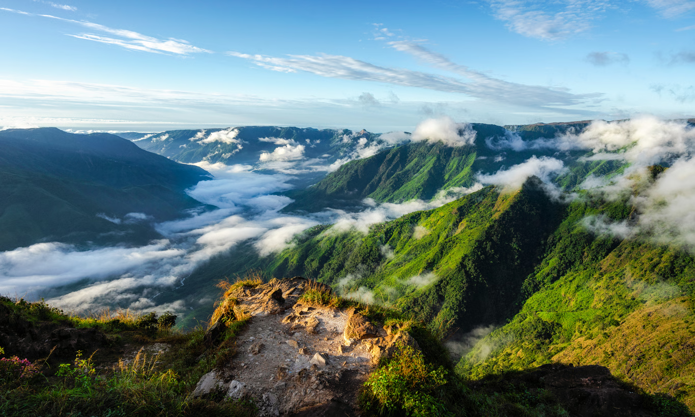
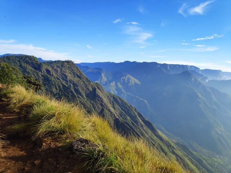
1. Laitlum Canyon Valley: Meghalaya's Signature Panorama
Laitlum Canyon is the valley view most travelers remember long after the trip. Located in East Khasi Hills, this ridge-edge viewpoint opens into dramatic layered valleys and deep gorges that fill with moving cloud bands in the morning. Official tourism references place Laitlum roughly 25 km from Shillong, making it one of the highest-value half-day excursions.
The name is commonly interpreted as 'end of hills,' and the landscape matches that feeling. You stand at the edge of a vast drop where the plateau breaks into a complex valley system. On clear days, the depth of the terrain becomes obvious; on misty days, the scene becomes moody and cinematic.
For first-time visitors, the best approach is early arrival. Dawn to mid-morning usually gives softer light and fewer crowds. If visibility is low, wait 20 to 40 minutes before leaving; weather often shifts quickly. Some sections include steep descending steps toward lower routes and villages, but casual visitors can still enjoy Laitlum without doing the full descent.
If this is your first Meghalaya trip, pair Laitlum with a city-side evening stop like Shillong Peak or Ward's Lake Shillong for a balanced day.
2. Sohra-Cherrapunji Valley: Rain-Carved Escarpments and Root-Bridge Terrain
Sohra (Cherrapunji) is not just a rainfall headline destination; it is a valley system of cliffs, monsoon-fed streams, and deep green escarpments. Tourism sources highlight Sohra for living root bridges, waterfalls, and adventure stops along the route, and this is exactly why the valley experience here feels different from Laitlum. Instead of one main panorama, Sohra gives multiple valley faces through the day.
Drive from Shillong via SH-5 and you will pass changing topography: forest ridges, dramatic drop-offs, and cloud channels that move across road bends. The key to enjoying the Cherrapunji valley zone is to treat it as a corridor, not a single point. Combine viewpoints, short walks, and one signature activity like root-bridge trekking.
For deeper planning, use these supporting guides: Cherrapunji tourist places, living root bridges in Meghalaya, and waterfalls in Cherrapunji. Together they build a strong full-day or 2-day Sohra valley itinerary.
October to March offers clearer trail conditions and safer movement on steps. Monsoon brings maximum green intensity and stronger waterfall flow, but road fog, slippery surfaces, and sudden rain can reduce flexibility. Choose your season based on comfort vs drama.
3. Mawphlang Valley: Sacred Landscapes and Khasi Heritage
Mawphlang is often described only through its sacred forest, but the larger valley landscape around it deserves equal attention. Rolling meadow-like slopes, forest edges, and old settlement routes create a calmer, heritage-rich valley experience compared with dramatic canyon viewpoints.
This zone works best for travelers who want nature plus cultural context. You can spend time in the sacred grove area, then move through nearby valley stretches to understand how communities, forest conservation traditions, and terrain evolved together. The rhythm is slower and less commercial, making it excellent for reflective travelers, couples, and photographers who prefer detail over checklist tourism.
A practical half-day Mawphlang plan includes: early departure from Shillong, guided sacred-grove walk, short valley road loop, and a late lunch return. Pairing Mawphlang with central Shillong in the same day is realistic if you start early and avoid overloading stops.
If you are exploring Meghalaya's nature systems in sequence, combine Mawphlang with Khasi Hills in Meghalaya for a broader landscape narrative.
4. Mawsynram Valley: The Wettest Place on Earth Experience
Mawsynram's global identity comes from rainfall, but the valley is more than a weather statistic. It is a cloud-dominated terrain where moisture, limestone features, and steep green gradients shape everything from visibility to movement timing. Tourism references consistently highlight the region's rain profile, nearby cave systems, and village-led stays.
In practical travel terms, Mawsynram valley rewards patience. Visibility can shift from wide open to near-whiteout within minutes during active weather. For photographers and slow travelers, this unpredictability is part of the appeal. For checklist travelers on tight schedules, it can feel challenging.
The best way to experience this valley is to keep buffer time and limit fixed expectations. Add one cave or geological point, one scenic valley halt, and one local food break instead of rushing through many stops. In dry months, you get easier road movement and cleaner horizon lines. In monsoon, you get a heavier atmospheric mood and intensely green frames.
For route continuity, Mawsynram is often included as a separate day from Sohra. Combining both in one rushed day usually reduces quality at each stop.
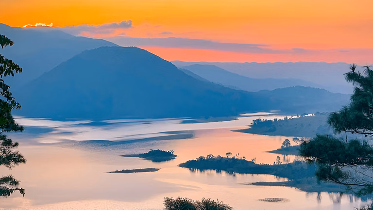
5. Barapani-Umiam Valley: Scenic Gateway Near Shillong
Umiam (Barapani) is frequently treated as a lake stop, but the surrounding valley setting is what creates its visual power. Official tourism material positions Umiam as a major gateway view on the Guwahati-Shillong route, with hills wrapping around broad water surfaces and changing cloud layers throughout the day.
This is one of the easiest valley experiences to add even on short trips. You can pause here on arrival from Guwahati, use it as a sunrise point before a day trip, or keep it for sunset when the water mirrors late light. Because Umiam is accessible and less physically demanding than canyon routes, it works well for mixed-age groups and relaxed itineraries.
Travelers looking for activity can include light water-based options, while others can focus on viewpoint photography and short lakeside breaks. Umiam also acts as a pace-reset stop between intense road sections to Sohra or Mawsynram.
For extended planning, see Umiam Lake Shillong and road trip from Guwahati to Shillong.
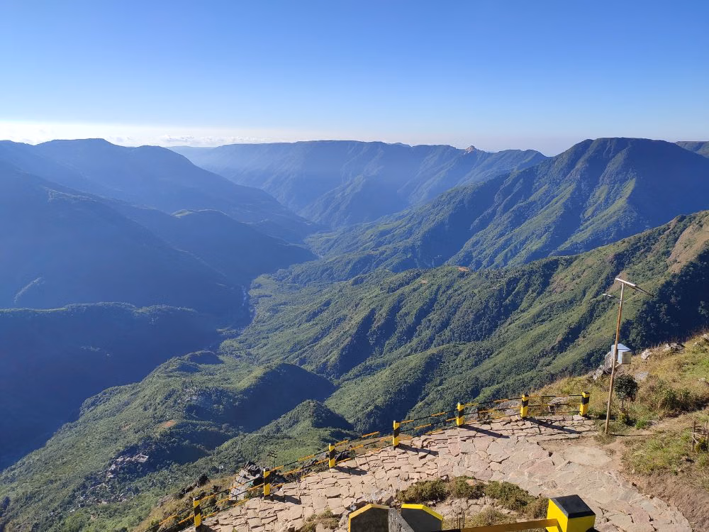
6. Mawkdok-Dympep Valley: The V-Shaped Gorge on the Sohra Route
Mawkdok-Dympep is one of the most photogenic valley halts between Shillong and Sohra. Meghalaya Tourism describes this stop as a deep V-shaped gorge viewpoint near the Duwan Sing Syiem bridge area, with options for adventure activities and strong roadside accessibility.
This valley stop works because it delivers immediate scale without long trekking. You park, walk to the edge, and get dramatic depth views within minutes. It is ideal for travelers who want a high-impact scenic break on a packed itinerary. Many visitors stop for 20 to 45 minutes, but serious photographers may wait longer for cloud movement and light transitions.
If you want a structured day, combine Mawkdok with Sohra viewpoints and one longer activity later. Do not spend your entire energy budget at the first stop, especially in monsoon when weather can delay movement. Keep schedule flexibility.
Read more in Mawkdok-Dympep Valley viewpoint guide to plan route timing and stop order.
7. Wahthala Valley Sector: A Quieter Extension for Repeat Travelers
Wahthala is often approached as a quieter valley extension in the Sohra belt, preferred by travelers who want less crowded ridge views and local-route exploration instead of only high-traffic points. The experience here is less about one iconic marker and more about atmosphere: open slopes, cloud drift, and road-edge panoramas that change every few kilometers.
Because local route names and stop labels can vary, this valley sector is best explored with current local guidance rather than rigid map-only planning. If you are on your first Meghalaya trip with limited days, prioritize Laitlum, Sohra, and Mawkdok first. If you have a second or third visit, Wahthala-type quieter routes add freshness and depth.
Keep expectations practical: fewer facilities, fewer signboards, and higher dependency on weather. But for travelers who enjoy less scripted landscapes, this is often one of the most rewarding valley drives in Meghalaya.
Best Time to Visit Valleys in Meghalaya
October to April (Best for Most Travelers)
This period is usually the easiest for planning. Roads are generally more predictable, skies are clearer, and valley views are more consistent. It is ideal for first-time visitors, families, and people with strict trip timelines.
June to September (Monsoon Drama)
This is the season of peak greenery, rushing waterfalls, and immersive cloudscapes. It is also the season of wet roads, reduced visibility, and sudden rain disruptions. Good for travelers comfortable with flexible plans.
Shoulder Months
Late September and early May can offer a useful compromise: greener terrain than peak dry season with relatively manageable movement conditions.
How to Reach and Plan Valley Circuits
- Nearest major airport: Guwahati (widest flight options), then road transfer to Shillong and onward valleys.
- Shillong base strategy: Use Shillong as your hub for Laitlum, Mawphlang, Umiam, and selected Sohra/Mawsynram day routes.
- 2-day valley circuit: Day 1 Laitlum + Umiam + Shillong city points; Day 2 Sohra corridor with Mawkdok and one activity cluster.
- 3-day valley circuit: Add Mawsynram as a dedicated weather-focused day with buffer timing.
Before finalizing routes, check how to reach Meghalaya and best time to visit Meghalaya for current travel windows.
Travel Tips for Valley Trips in Meghalaya
- Start early. Morning windows give the best light and better road pace.
- Carry a rain layer in every season; weather shifts are fast.
- Avoid overpacking one day with too many distant stops.
- Keep offline maps and cash backup for remote stretches.
- Respect local customs, private land boundaries, and eco-rules.
- In monsoon, prioritize safety over viewpoint chasing.
Valleys in Meghalaya are best experienced slowly. A realistic route with fewer, deeper stops almost always delivers a better trip than a long list of rushed check-ins.
Final Takeaway
If you want a strong first Meghalaya plan, begin with Laitlum Canyon, Sohra valley routes, Mawkdok-Dympep, and Umiam. Add Mawphlang for culture and Mawsynram for rain geography. Use Wahthala-style quieter sectors when you have extra time or prefer less crowded landscapes.
The magic of Meghalaya's valleys is not one single viewpoint. It is the movement between cloud, cliff, forest, and village terrain through the day. Plan with weather awareness, keep timing buffers, and these valleys will become the highlight of your Northeast itinerary.
Location
Frequently Asked Questions
Q1.Which is the most beautiful valley in Meghalaya?
Q2.How many days are needed to explore Meghalaya valleys?
Q3.Where is Laitlum Canyon located?
Q4.Which Meghalaya valley has living root bridges?
Q5.How far is Cherrapunji from Shillong?
Q6.Is it safe to visit Meghalaya valleys during monsoon?
Q7.What is the best time to visit valleys in Meghalaya?
Q8.Can Meghalaya valley trips be done from Shillong as day tours?
Recommended For You
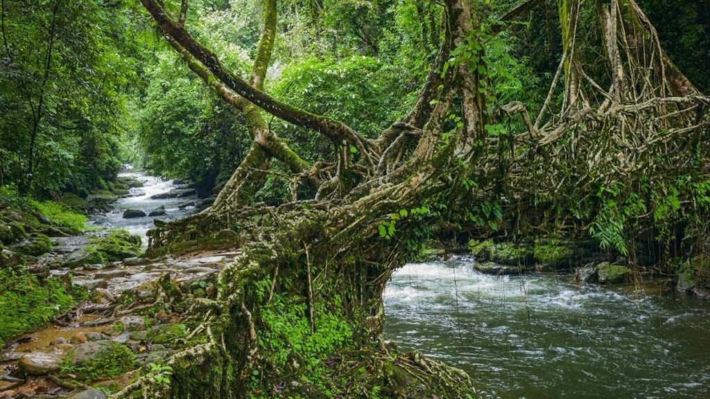
Living Root Bridges Meghalaya: Trek Routes, Villages & Local Tips
Discover Meghalaya's incredible living root bridges - nature's bioengineering marvel grown by the Khasi tribes. Complete trekking guide to the Double Decker Root Bridge in Nongriat, best time to visit, how to reach, difficulty level, and photography tips.
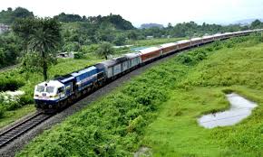
How to Reach Meghalaya: Flight, Train, Road & Entry Points
Complete guide on how to reach Meghalaya by flight, train & road. Routes from Guwahati, Kolkata, Delhi with timings, distances & travel tips.
Best Time to Visit Meghalaya: Rainfall, Season & Waterfall Views
Understand Meghalaya weather by season with practical month-wise planning tips for waterfalls, root bridges, caving, and safer route timing.
Never Miss an Adventure
Get the latest trekking guides, travel tips, and exclusive offers delivered straight to your inbox.